You are here: Home > Network List > US - United States National Seismic Network Stations List
> Station WMOK Wichita Mountains, Oklahoma, USA > Earthquake Result Viewer
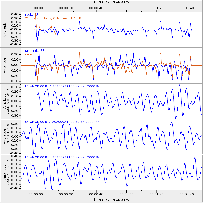
WMOK Wichita Mountains, Oklahoma, USA - Earthquake Result Viewer
*The percent match for this event was below the threshold and hence no stack was calculated.
| Earthquake location: |
Central Mid-Atlantic Ridge |
| Earthquake latitude/longitude: |
-0.3/-18.8 |
| Earthquake time(UTC): |
2020/09/24 (268) 00:27:49 GMT |
| Earthquake Depth: |
10 km |
| Earthquake Magnitude: |
5.7 Mww |
| Earthquake Catalog/Contributor: |
NEIC PDE/us |
|
| Network: |
US United States National Seismic Network |
| Station: |
WMOK Wichita Mountains, Oklahoma, USA |
| Lat/Lon: |
34.74 N/98.78 W |
| Elevation: |
486 m |
|
| Distance: |
81.9 deg |
| Az: |
305.005 deg |
| Baz: |
95.966 deg |
| Ray Param: |
$rayparam |
*The percent match for this event was below the threshold and hence was not used in the summary stack. |
|
| Radial Match: |
47.76453 % |
| Radial Bump: |
400 |
| Transverse Match: |
51.930042 % |
| Transverse Bump: |
400 |
| SOD ConfigId: |
22732711 |
| Insert Time: |
2020-10-08 00:41:40.761 +0000 |
| GWidth: |
2.5 |
| Max Bumps: |
400 |
| Tol: |
0.001 |
|
Signal To Noise
| Channel | StoN | STA | LTA |
| US:WMOK:00:BHZ:20200924T00:39:37.700018Z | 1.1948469 | 2.3576796E-7 | 1.9732065E-7 |
| US:WMOK:00:BH1:20200924T00:39:37.700018Z | 0.87108934 | 1.07463315E-7 | 1.2336659E-7 |
| US:WMOK:00:BH2:20200924T00:39:37.700018Z | 1.3500749 | 1.6946343E-7 | 1.255215E-7 |
| Arrivals |
| Ps | |
| PpPs | |
| PsPs/PpSs | |


