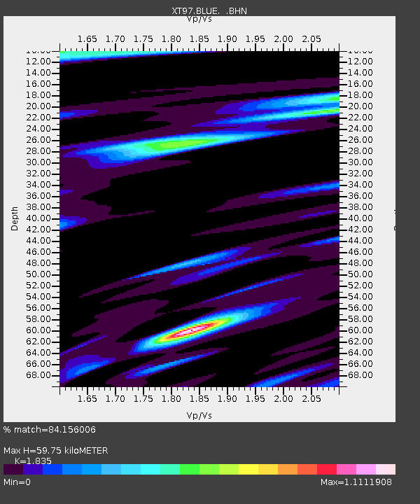
BLUE XT.BLUE - Earthquake Result Viewer

Earthquake location: Rat Islands, Aleutian Islands
Earthquake latitude/longitude: 51.2/178.9
Earthquake time(UTC): 1997/12/17 (351) 04:38:51 GMT
Earthquake Depth: 20 km
Earthquake Magnitude: 5.8 MB, 6.5 MS, 6.7 UNKNOWN, 6.1 ME
Earthquake Catalog/Contributor: WHDF/NEIC
Network: XT Colorado BB Array - Lodore
Station: BLUE XT.BLUE
Lat/Lon: 40.99 N/108.54 W
Elevation: 2098 m
Distance: 49.4 deg
Az: 71.964 deg
Baz: 307.765 deg
Ray Param: 0.06868056
Estimated Moho Depth: 59.75 km
Estimated Crust Vp/Vs: 1.84
Assumed Crust Vp: 6.207 km/s
Estimated Crust Vs: 3.383 km/s
Estimated Crust Poisson's Ratio: 0.29
Radial Match: 84.156006 %
Radial Bump: 400
Transverse Match: 55.664375 %
Transverse Bump: 400
SOD ConfigId: 4480
Insert Time: 2010-03-09 01:26:26.570 +0000
GWidth: 2.5
Max Bumps: 400
Tol: 0.001

Signal To Noise

ChannelStoNSTALTA
XT:BLUE: :BHN:19971217T04:47:09.000006Z3.1534361.5997498E-65.0730375E-7
XT:BLUE: :BHE:19971217T04:47:09.000006Z1.74094528.9789347E-75.1575057E-7
XT:BLUE: :BHZ:19971217T04:47:09.000006Z0.845450465.0124146E-75.9286907E-7
Arrivals
Ps8.5 SECOND
PpPs26 SECOND
PsPs/PpSs34 SECOND