You are here: Home > Network List > AZ - ANZA Regional Network Stations List
> Station SMER AZ.SMER > Earthquake Result Viewer
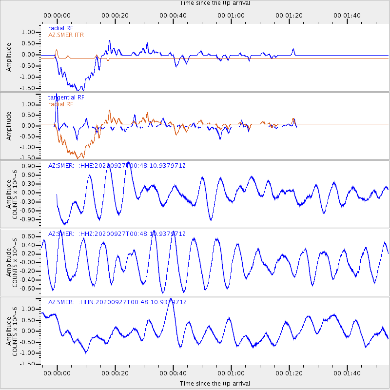
SMER AZ.SMER - Earthquake Result Viewer
*The percent match for this event was below the threshold and hence no stack was calculated.
| Earthquake location: |
Pacific-Antarctic Ridge |
| Earthquake latitude/longitude: |
-57.2/-147.7 |
| Earthquake time(UTC): |
2020/09/27 (271) 00:35:24 GMT |
| Earthquake Depth: |
10 km |
| Earthquake Magnitude: |
5.5 Mww |
| Earthquake Catalog/Contributor: |
NEIC PDE/us |
|
| Network: |
AZ ANZA Regional Network |
| Station: |
SMER AZ.SMER |
| Lat/Lon: |
33.46 N/117.17 W |
| Elevation: |
355 m |
|
| Distance: |
93.9 deg |
| Az: |
25.208 deg |
| Baz: |
196.1 deg |
| Ray Param: |
$rayparam |
*The percent match for this event was below the threshold and hence was not used in the summary stack. |
|
| Radial Match: |
35.960415 % |
| Radial Bump: |
400 |
| Transverse Match: |
52.694916 % |
| Transverse Bump: |
400 |
| SOD ConfigId: |
22732711 |
| Insert Time: |
2020-10-11 00:36:46.860 +0000 |
| GWidth: |
2.5 |
| Max Bumps: |
400 |
| Tol: |
0.001 |
|
Signal To Noise
| Channel | StoN | STA | LTA |
| AZ:SMER: :HHZ:20200927T00:48:10.937971Z | 2.1872516 | 4.2665167E-7 | 1.9506291E-7 |
| AZ:SMER: :HHN:20200927T00:48:10.937971Z | 0.46943054 | 5.1708645E-7 | 1.1015185E-6 |
| AZ:SMER: :HHE:20200927T00:48:10.937971Z | 0.63047415 | 3.7707898E-7 | 5.98088E-7 |
| Arrivals |
| Ps | |
| PpPs | |
| PsPs/PpSs | |


