You are here: Home > Network List > XT97 - Colorado BB Array - Lodore Stations List
> Station CALI XT.CALI > Earthquake Result Viewer
CALI XT.CALI - Earthquake Result Viewer
| Earthquake location: |
Tonga Islands |
| Earthquake latitude/longitude: |
-21.3/-174.4 |
| Earthquake time(UTC): |
1997/09/10 (253) 12:57:07 GMT |
| Earthquake Depth: |
10 km |
| Earthquake Magnitude: |
5.7 MB, 6.1 MS, 6.1 UNKNOWN, 5.9 MW |
| Earthquake Catalog/Contributor: |
WHDF/NEIC |
|
| Network: |
XT Colorado BB Array - Lodore |
| Station: |
CALI XT.CALI |
| Lat/Lon: |
40.37 N/108.57 W |
| Elevation: |
2085 m |
|
| Distance: |
86.7 deg |
| Az: |
44.284 deg |
| Baz: |
238.414 deg |
| Ray Param: |
0.043890793 |
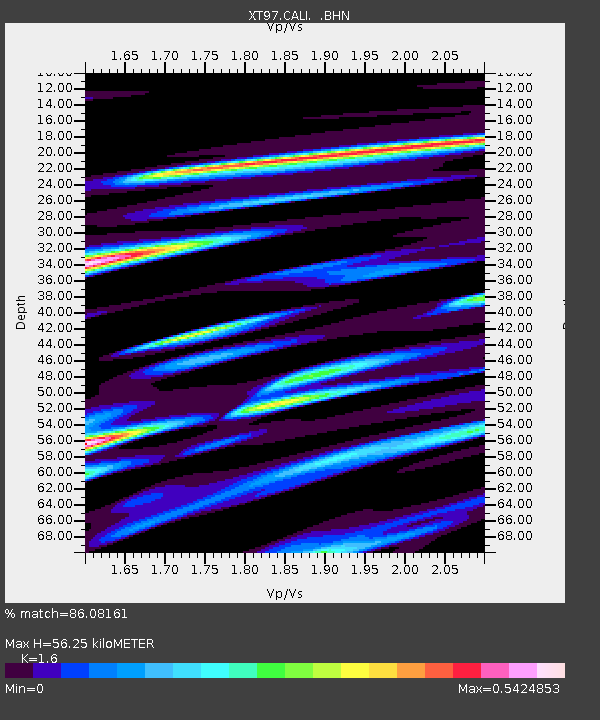
| Estimated Moho Depth: |
56.25 km |
| Estimated Crust Vp/Vs: |
1.60 |
| Assumed Crust Vp: |
6.207 km/s |
| Estimated Crust Vs: |
3.879 km/s |
| Estimated Crust Poisson's Ratio: |
0.18 |
|
| Radial Match: |
86.08161 % |
| Radial Bump: |
400 |
| Transverse Match: |
66.044495 % |
| Transverse Bump: |
400 |
| SOD ConfigId: |
6273 |
| Insert Time: |
2010-03-09 01:28:03.167 +0000 |
| GWidth: |
2.5 |
| Max Bumps: |
400 |
| Tol: |
0.001 |
|

Signal To Noise
| Channel | StoN | STA | LTA |
| XT:CALI: :BHN:19970910T13:09:19.200012Z | 1.4525095 | 1.3311474E-7 | 9.164466E-8 |
| XT:CALI: :BHE:19970910T13:09:19.200012Z | 1.2616782 | 1.3061636E-7 | 1.03525885E-7 |
| XT:CALI: :BHZ:19970910T13:09:19.200012Z | 3.125489 | 3.3142265E-7 | 1.06038655E-7 |
| Arrivals |
| Ps | 5.6 SECOND |
| PpPs | 23 SECOND |
| PsPs/PpSs | 29 SECOND |


