You are here: Home > Network List > WI - West Indies IPGP Network Stations List
> Station MPOM Morne Pois, Sainte-Anne, Martinique > Earthquake Result Viewer
MPOM Morne Pois, Sainte-Anne, Martinique - Earthquake Result Viewer
| Earthquake location: |
North Of Ascension Island |
| Earthquake latitude/longitude: |
-0.9/-13.9 |
| Earthquake time(UTC): |
2017/08/18 (230) 02:59:24 GMT |
| Earthquake Depth: |
19 km |
| Earthquake Magnitude: |
6.7 Mi |
| Earthquake Catalog/Contributor: |
NEIC PDE/pt |
|
| Network: |
WI West Indies IPGP Network |
| Station: |
MPOM Morne Pois, Sainte-Anne, Martinique |
| Lat/Lon: |
14.45 N/60.86 W |
| Elevation: |
50 m |
|
| Distance: |
48.9 deg |
| Az: |
290.008 deg |
| Baz: |
104.114 deg |
| Ray Param: |
0.06902467 |
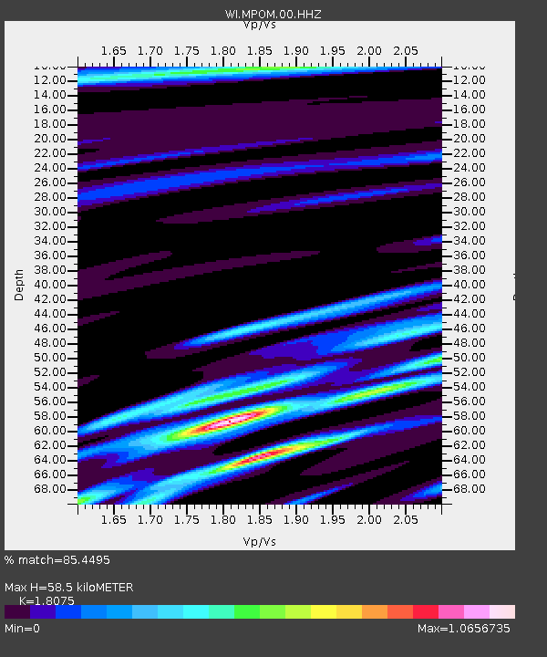
| Estimated Moho Depth: |
58.5 km |
| Estimated Crust Vp/Vs: |
1.81 |
| Assumed Crust Vp: |
5.88 km/s |
| Estimated Crust Vs: |
3.253 km/s |
| Estimated Crust Poisson's Ratio: |
0.28 |
|
| Radial Match: |
85.4495 % |
| Radial Bump: |
400 |
| Transverse Match: |
74.29121 % |
| Transverse Bump: |
400 |
| SOD ConfigId: |
2140511 |
| Insert Time: |
2017-08-31 19:03:27.665 +0000 |
| GWidth: |
2.5 |
| Max Bumps: |
400 |
| Tol: |
0.001 |
|

Signal To Noise
| Channel | StoN | STA | LTA |
| WI:MPOM:00:HHZ:20170818T03:07:37.700012Z | 0.63991207 | 3.153055E-7 | 4.9273257E-7 |
| WI:MPOM:00:HHN:20170818T03:07:37.700012Z | 0.8424907 | 3.744465E-7 | 4.444518E-7 |
| WI:MPOM:00:HHE:20170818T03:07:37.700012Z | 1.5108547 | 7.002855E-7 | 4.635029E-7 |
| Arrivals |
| Ps | 8.4 SECOND |
| PpPs | 27 SECOND |
| PsPs/PpSs | 35 SECOND |


