You are here: Home > Network List > GM - US Geological Survey Networks Stations List
> Station IWM01 Jericho 2M Well Monitoring Station > Earthquake Result Viewer
IWM01 Jericho 2M Well Monitoring Station - Earthquake Result Viewer
| Earthquake location: |
North Of Ascension Island |
| Earthquake latitude/longitude: |
-0.9/-13.9 |
| Earthquake time(UTC): |
2017/08/18 (230) 02:59:24 GMT |
| Earthquake Depth: |
19 km |
| Earthquake Magnitude: |
6.7 Mi |
| Earthquake Catalog/Contributor: |
NEIC PDE/pt |
|
| Network: |
GM US Geological Survey Networks |
| Station: |
IWM01 Jericho 2M Well Monitoring Station |
| Lat/Lon: |
36.73 N/96.53 W |
| Elevation: |
328 m |
|
| Distance: |
84.6 deg |
| Az: |
306.838 deg |
| Baz: |
95.093 deg |
| Ray Param: |
0.045342546 |
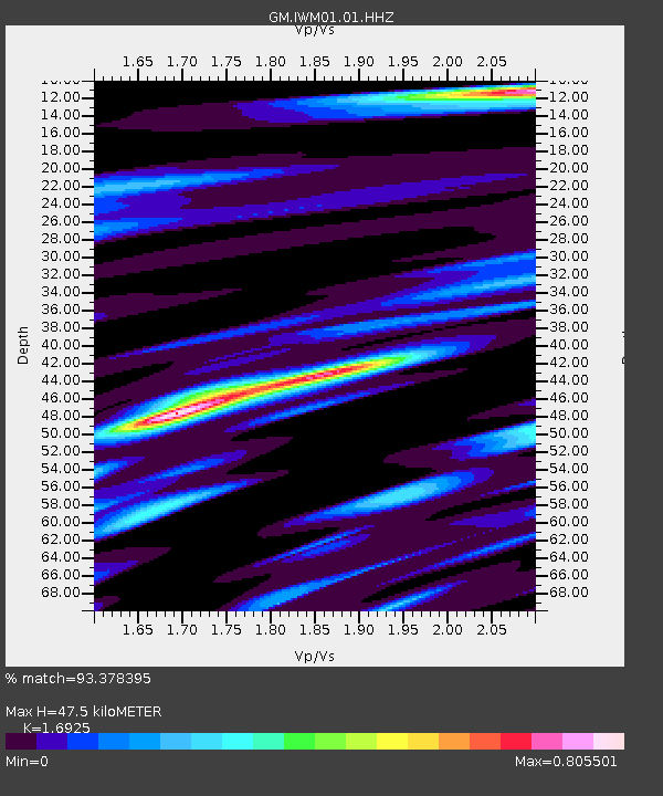
| Estimated Moho Depth: |
47.5 km |
| Estimated Crust Vp/Vs: |
1.69 |
| Assumed Crust Vp: |
6.483 km/s |
| Estimated Crust Vs: |
3.83 km/s |
| Estimated Crust Poisson's Ratio: |
0.23 |
|
| Radial Match: |
93.378395 % |
| Radial Bump: |
400 |
| Transverse Match: |
72.0978 % |
| Transverse Bump: |
400 |
| SOD ConfigId: |
2140511 |
| Insert Time: |
2017-08-31 19:05:16.009 +0000 |
| GWidth: |
2.5 |
| Max Bumps: |
400 |
| Tol: |
0.001 |
|
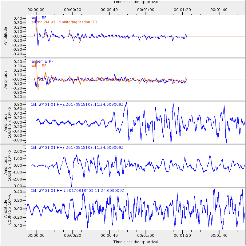
Signal To Noise
| Channel | StoN | STA | LTA |
| GM:IWM01:01:HHZ:20170818T03:11:24.609009Z | 0.99336016 | 7.81101E-8 | 7.8632205E-8 |
| GM:IWM01:01:HHN:20170818T03:11:24.609009Z | 0.69175595 | 7.729381E-8 | 1.1173567E-7 |
| GM:IWM01:01:HHE:20170818T03:11:24.609009Z | 1.3455943 | 8.88946E-8 | 6.606345E-8 |
| Arrivals |
| Ps | 5.2 SECOND |
| PpPs | 19 SECOND |
| PsPs/PpSs | 24 SECOND |


