You are here: Home > Network List > US - United States National Seismic Network Stations List
> Station MNTX Cornudas Mountains, Texas, USA > Earthquake Result Viewer
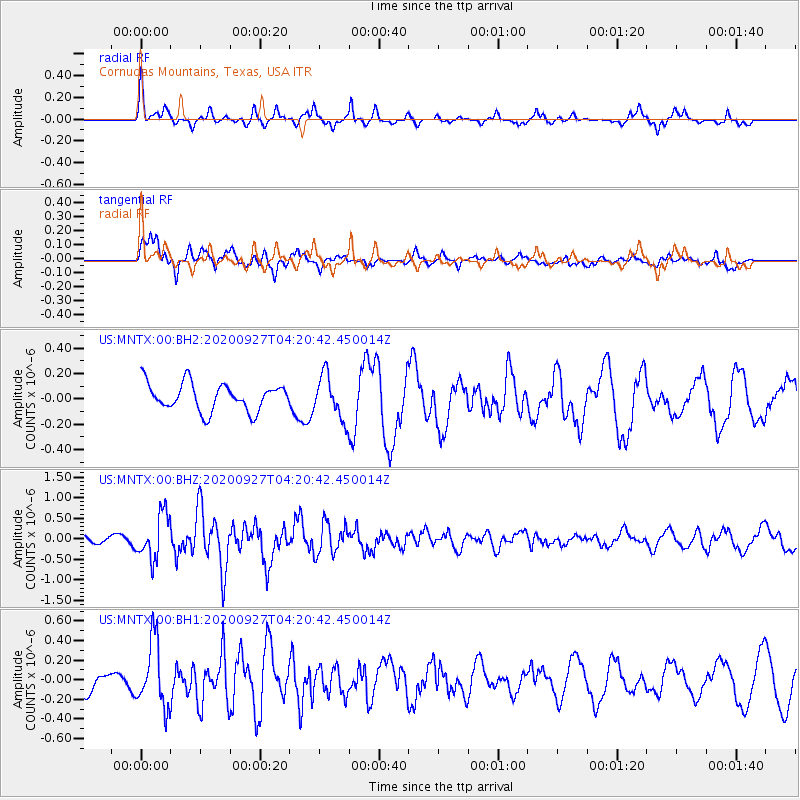
MNTX Cornudas Mountains, Texas, USA - Earthquake Result Viewer
*The percent match for this event was below the threshold and hence no stack was calculated.
| Earthquake location: |
Fox Islands, Aleutian Islands |
| Earthquake latitude/longitude: |
51.9/-169.8 |
| Earthquake time(UTC): |
2020/09/27 (271) 04:12:17 GMT |
| Earthquake Depth: |
14 km |
| Earthquake Magnitude: |
5.6 mww |
| Earthquake Catalog/Contributor: |
NEIC PDE/us |
|
| Network: |
US United States National Seismic Network |
| Station: |
MNTX Cornudas Mountains, Texas, USA |
| Lat/Lon: |
31.70 N/105.38 W |
| Elevation: |
404 m |
|
| Distance: |
50.3 deg |
| Az: |
87.441 deg |
| Baz: |
313.48 deg |
| Ray Param: |
$rayparam |
*The percent match for this event was below the threshold and hence was not used in the summary stack. |
|
| Radial Match: |
61.37918 % |
| Radial Bump: |
277 |
| Transverse Match: |
72.0667 % |
| Transverse Bump: |
383 |
| SOD ConfigId: |
22732711 |
| Insert Time: |
2020-10-11 04:34:36.649 +0000 |
| GWidth: |
2.5 |
| Max Bumps: |
400 |
| Tol: |
0.001 |
|
Signal To Noise
| Channel | StoN | STA | LTA |
| US:MNTX:00:BHZ:20200927T04:20:42.450014Z | 5.810608 | 5.3810743E-7 | 9.260776E-8 |
| US:MNTX:00:BH1:20200927T04:20:42.450014Z | 1.7389059 | 3.3440799E-7 | 1.9230941E-7 |
| US:MNTX:00:BH2:20200927T04:20:42.450014Z | 1.6011858 | 1.7218882E-7 | 1.0753831E-7 |
| Arrivals |
| Ps | |
| PpPs | |
| PsPs/PpSs | |


