You are here: Home > Network List > XT97 - Colorado BB Array - Lodore Stations List
> Station CSD XT.CSD > Earthquake Result Viewer
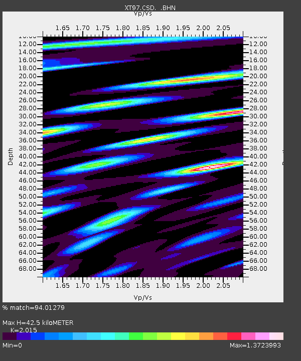
CSD XT.CSD - Earthquake Result Viewer
| Earthquake location: |
Fiji Islands Region |
| Earthquake latitude/longitude: |
-17.6/-179.1 |
| Earthquake time(UTC): |
1998/03/29 (088) 19:48:16 GMT |
| Earthquake Depth: |
537 km |
| Earthquake Magnitude: |
6.5 MB, 7.2 UNKNOWN, 7.1 MW |
| Earthquake Catalog/Contributor: |
WHDF/NEIC |
|
| Network: |
XT Colorado BB Array - Lodore |
| Station: |
CSD XT.CSD |
| Lat/Lon: |
40.44 N/108.28 W |
| Elevation: |
1931 m |
|
| Distance: |
87.4 deg |
| Az: |
46.189 deg |
| Baz: |
244.418 deg |
| Ray Param: |
0.041870374 |
| Estimated Moho Depth: |
42.5 km |
| Estimated Crust Vp/Vs: |
2.02 |
| Assumed Crust Vp: |
6.207 km/s |
| Estimated Crust Vs: |
3.08 km/s |
| Estimated Crust Poisson's Ratio: |
0.34 |
|
| Radial Match: |
94.01279 % |
| Radial Bump: |
346 |
| Transverse Match: |
93.92785 % |
| Transverse Bump: |
400 |
| SOD ConfigId: |
4480 |
| Insert Time: |
2010-03-09 01:29:27.713 +0000 |
| GWidth: |
2.5 |
| Max Bumps: |
400 |
| Tol: |
0.001 |
|

Signal To Noise
| Channel | StoN | STA | LTA |
| XT:CSD: :BHN:19980329T19:59:34.975024Z | 110.16093 | 1.6652164E-5 | 1.5116217E-7 |
| XT:CSD: :BHE:19980329T19:59:34.975024Z | 6.669578 | 1.867178E-6 | 2.7995443E-7 |
| XT:CSD: :BHZ:19980329T19:59:34.975024Z | 11.700512 | 3.500494E-6 | 2.9917442E-7 |
| Arrivals |
| Ps | 7.1 SECOND |
| PpPs | 20 SECOND |
| PsPs/PpSs | 27 SECOND |


