You are here: Home > Network List > AU - Australian Seismological Centre Stations List
> Station PSAB1 Pilbara Seismic Array Element B1 > Earthquake Result Viewer
PSAB1 Pilbara Seismic Array Element B1 - Earthquake Result Viewer
| Earthquake location: |
Fiji Islands Region |
| Earthquake latitude/longitude: |
-18.0/-178.9 |
| Earthquake time(UTC): |
2017/08/19 (231) 02:00:52 GMT |
| Earthquake Depth: |
539 km |
| Earthquake Magnitude: |
6.4 Mww |
| Earthquake Catalog/Contributor: |
NEIC PDE/us |
|
| Network: |
AU Australian Seismological Centre |
| Station: |
PSAB1 Pilbara Seismic Array Element B1 |
| Lat/Lon: |
21.57 S/119.82 E |
| Elevation: |
317 m |
|
| Distance: |
57.5 deg |
| Az: |
255.515 deg |
| Baz: |
98.072 deg |
| Ray Param: |
0.061262034 |
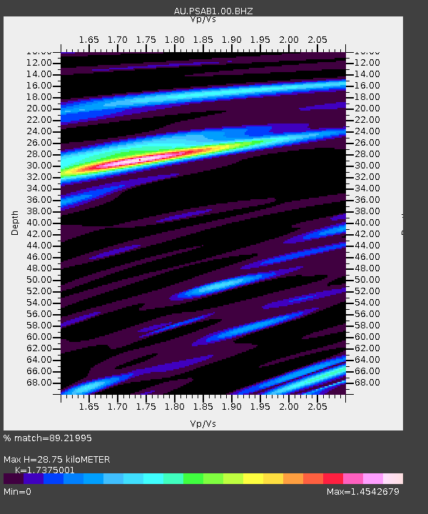
| Estimated Moho Depth: |
28.75 km |
| Estimated Crust Vp/Vs: |
1.74 |
| Assumed Crust Vp: |
6.464 km/s |
| Estimated Crust Vs: |
3.72 km/s |
| Estimated Crust Poisson's Ratio: |
0.25 |
|
| Radial Match: |
89.21995 % |
| Radial Bump: |
400 |
| Transverse Match: |
76.71613 % |
| Transverse Bump: |
400 |
| SOD ConfigId: |
2140511 |
| Insert Time: |
2017-09-01 17:56:54.945 +0000 |
| GWidth: |
2.5 |
| Max Bumps: |
400 |
| Tol: |
0.001 |
|

Signal To Noise
| Channel | StoN | STA | LTA |
| AU:PSAB1:00:BHZ:20170819T02:09:19.144004Z | 21.555878 | 9.441579E-6 | 4.3800486E-7 |
| AU:PSAB1:00:BH1:20170819T02:09:19.144004Z | 13.560406 | 4.786022E-6 | 3.529409E-7 |
| AU:PSAB1:00:BH2:20170819T02:09:19.144004Z | 3.5394552 | 1.0341505E-6 | 2.9217787E-7 |
| Arrivals |
| Ps | 3.4 SECOND |
| PpPs | 12 SECOND |
| PsPs/PpSs | 15 SECOND |


