You are here: Home > Network List > AE - Arizona Broadband Seismic Network Stations List
> Station HANNA Alpine/Hannagan Meadow > Earthquake Result Viewer
HANNA Alpine/Hannagan Meadow - Earthquake Result Viewer
| Earthquake location: |
Tonga Islands |
| Earthquake latitude/longitude: |
-19.1/-173.6 |
| Earthquake time(UTC): |
2020/10/01 (275) 01:13:39 GMT |
| Earthquake Depth: |
10 km |
| Earthquake Magnitude: |
6.7 Mi |
| Earthquake Catalog/Contributor: |
NEIC PDE/at |
|
| Network: |
AE Arizona Broadband Seismic Network |
| Station: |
HANNA Alpine/Hannagan Meadow |
| Lat/Lon: |
33.64 N/109.32 W |
| Elevation: |
2796 m |
|
| Distance: |
80.6 deg |
| Az: |
49.625 deg |
| Baz: |
239.711 deg |
| Ray Param: |
0.048157323 |
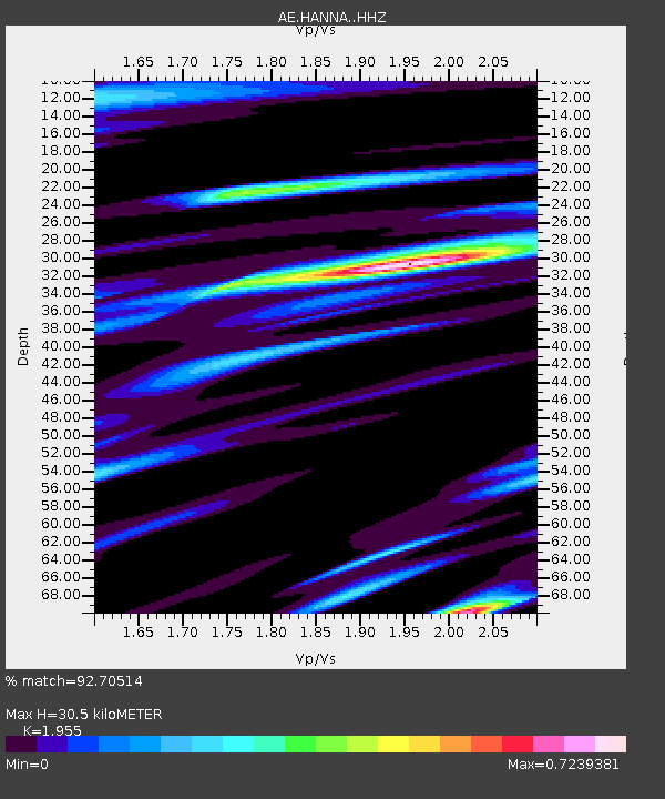
| Estimated Moho Depth: |
30.5 km |
| Estimated Crust Vp/Vs: |
1.96 |
| Assumed Crust Vp: |
6.276 km/s |
| Estimated Crust Vs: |
3.21 km/s |
| Estimated Crust Poisson's Ratio: |
0.32 |
|
| Radial Match: |
92.70514 % |
| Radial Bump: |
378 |
| Transverse Match: |
81.968124 % |
| Transverse Bump: |
400 |
| SOD ConfigId: |
22732711 |
| Insert Time: |
2020-10-15 01:15:15.077 +0000 |
| GWidth: |
2.5 |
| Max Bumps: |
400 |
| Tol: |
0.001 |
|

Signal To Noise
| Channel | StoN | STA | LTA |
| AE:HANNA: :HHZ:20201001T01:25:20.31897Z | 40.25344 | 4.759727E-6 | 1.18243975E-7 |
| AE:HANNA: :HHN:20201001T01:25:20.31897Z | 4.749 | 8.880032E-7 | 1.869874E-7 |
| AE:HANNA: :HHE:20201001T01:25:20.31897Z | 14.11445 | 1.5823383E-6 | 1.1210768E-7 |
| Arrivals |
| Ps | 4.8 SECOND |
| PpPs | 14 SECOND |
| PsPs/PpSs | 19 SECOND |


