You are here: Home > Network List > AK - Alaska Regional Network Stations List
> Station CCB Clear Creek Butte > Earthquake Result Viewer
CCB Clear Creek Butte - Earthquake Result Viewer
| Earthquake location: |
Tonga Islands |
| Earthquake latitude/longitude: |
-19.1/-173.6 |
| Earthquake time(UTC): |
2020/10/01 (275) 01:13:39 GMT |
| Earthquake Depth: |
10 km |
| Earthquake Magnitude: |
6.7 Mi |
| Earthquake Catalog/Contributor: |
NEIC PDE/at |
|
| Network: |
AK Alaska Regional Network |
| Station: |
CCB Clear Creek Butte |
| Lat/Lon: |
64.65 N/147.80 W |
| Elevation: |
248 m |
|
| Distance: |
85.8 deg |
| Az: |
10.829 deg |
| Baz: |
204.37 deg |
| Ray Param: |
0.04449577 |
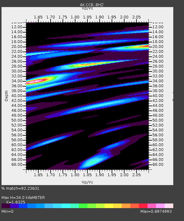
| Estimated Moho Depth: |
34.0 km |
| Estimated Crust Vp/Vs: |
1.63 |
| Assumed Crust Vp: |
6.566 km/s |
| Estimated Crust Vs: |
4.022 km/s |
| Estimated Crust Poisson's Ratio: |
0.20 |
|
| Radial Match: |
92.23631 % |
| Radial Bump: |
400 |
| Transverse Match: |
87.24525 % |
| Transverse Bump: |
400 |
| SOD ConfigId: |
22732711 |
| Insert Time: |
2020-10-15 01:16:01.203 +0000 |
| GWidth: |
2.5 |
| Max Bumps: |
400 |
| Tol: |
0.001 |
|

Signal To Noise
| Channel | StoN | STA | LTA |
| AK:CCB: :BHZ:20201001T01:25:47.028015Z | 14.182485 | 2.81653E-6 | 1.9859213E-7 |
| AK:CCB: :BHN:20201001T01:25:47.028015Z | 5.69735 | 1.0422423E-6 | 1.8293457E-7 |
| AK:CCB: :BHE:20201001T01:25:47.028015Z | 5.35047 | 9.353832E-7 | 1.7482262E-7 |
| Arrivals |
| Ps | 3.4 SECOND |
| PpPs | 13 SECOND |
| PsPs/PpSs | 17 SECOND |


