You are here: Home > Network List > AK - Alaska Regional Network Stations List
> Station U33K Whale Pass, AK, USA > Earthquake Result Viewer
U33K Whale Pass, AK, USA - Earthquake Result Viewer
| Earthquake location: |
Tonga Islands |
| Earthquake latitude/longitude: |
-19.1/-173.6 |
| Earthquake time(UTC): |
2020/10/01 (275) 01:13:39 GMT |
| Earthquake Depth: |
10 km |
| Earthquake Magnitude: |
6.7 Mi |
| Earthquake Catalog/Contributor: |
NEIC PDE/at |
|
| Network: |
AK Alaska Regional Network |
| Station: |
U33K Whale Pass, AK, USA |
| Lat/Lon: |
56.11 N/133.12 W |
| Elevation: |
11 m |
|
| Distance: |
82.3 deg |
| Az: |
21.524 deg |
| Baz: |
218.273 deg |
| Ray Param: |
0.046963833 |
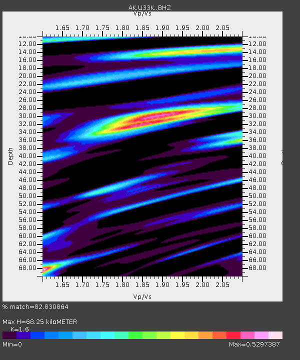
| Estimated Moho Depth: |
68.25 km |
| Estimated Crust Vp/Vs: |
1.60 |
| Assumed Crust Vp: |
6.597 km/s |
| Estimated Crust Vs: |
4.123 km/s |
| Estimated Crust Poisson's Ratio: |
0.18 |
|
| Radial Match: |
82.830864 % |
| Radial Bump: |
326 |
| Transverse Match: |
64.46632 % |
| Transverse Bump: |
324 |
| SOD ConfigId: |
22732711 |
| Insert Time: |
2020-10-15 01:18:16.043 +0000 |
| GWidth: |
2.5 |
| Max Bumps: |
400 |
| Tol: |
0.001 |
|

Signal To Noise
| Channel | StoN | STA | LTA |
| AK:U33K: :BHZ:20201001T01:25:29.380005Z | 7.167002 | 3.249227E-6 | 4.5335926E-7 |
| AK:U33K: :BHN:20201001T01:25:29.380005Z | 2.6585248 | 7.6817395E-7 | 2.8894743E-7 |
| AK:U33K: :BHE:20201001T01:25:29.380005Z | 1.5822185 | 6.892764E-7 | 4.3563918E-7 |
| Arrivals |
| Ps | 6.4 SECOND |
| PpPs | 26 SECOND |
| PsPs/PpSs | 32 SECOND |


