You are here: Home > Network List > AK - Alaska Regional Network Stations List
> Station C16K Lisburne Hills, AK, USA > Earthquake Result Viewer
C16K Lisburne Hills, AK, USA - Earthquake Result Viewer
| Earthquake location: |
Tonga Islands |
| Earthquake latitude/longitude: |
-19.1/-173.6 |
| Earthquake time(UTC): |
2020/10/01 (275) 01:13:39 GMT |
| Earthquake Depth: |
10 km |
| Earthquake Magnitude: |
6.7 Mi |
| Earthquake Catalog/Contributor: |
NEIC PDE/at |
|
| Network: |
AK Alaska Regional Network |
| Station: |
C16K Lisburne Hills, AK, USA |
| Lat/Lon: |
68.27 N/165.34 W |
| Elevation: |
102 m |
|
| Distance: |
87.3 deg |
| Az: |
3.068 deg |
| Baz: |
187.813 deg |
| Ray Param: |
0.04339767 |
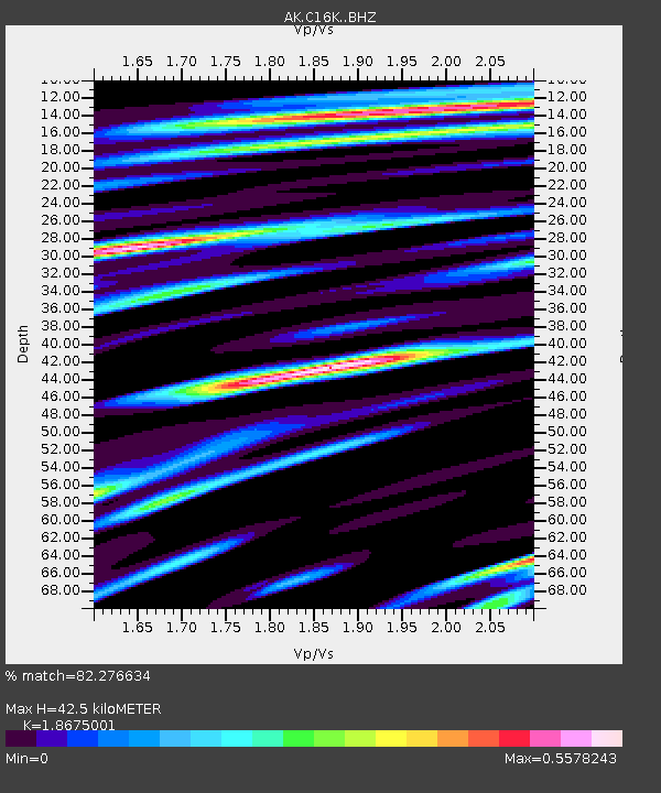
| Estimated Moho Depth: |
42.5 km |
| Estimated Crust Vp/Vs: |
1.87 |
| Assumed Crust Vp: |
5.906 km/s |
| Estimated Crust Vs: |
3.163 km/s |
| Estimated Crust Poisson's Ratio: |
0.30 |
|
| Radial Match: |
82.276634 % |
| Radial Bump: |
400 |
| Transverse Match: |
73.32172 % |
| Transverse Bump: |
400 |
| SOD ConfigId: |
22732711 |
| Insert Time: |
2020-10-15 01:18:51.053 +0000 |
| GWidth: |
2.5 |
| Max Bumps: |
400 |
| Tol: |
0.001 |
|

Signal To Noise
| Channel | StoN | STA | LTA |
| AK:C16K: :BHZ:20201001T01:25:54.460022Z | 7.601575 | 1.1075964E-6 | 1.4570618E-7 |
| AK:C16K: :BHN:20201001T01:25:54.460022Z | 2.376937 | 3.2201498E-7 | 1.3547476E-7 |
| AK:C16K: :BHE:20201001T01:25:54.460022Z | 1.8942643 | 2.5878273E-7 | 1.3661385E-7 |
| Arrivals |
| Ps | 6.4 SECOND |
| PpPs | 20 SECOND |
| PsPs/PpSs | 27 SECOND |


