You are here: Home > Network List > AK - Alaska Regional Network Stations List
> Station G17K Kiwalik Mountain, AK, USA > Earthquake Result Viewer
G17K Kiwalik Mountain, AK, USA - Earthquake Result Viewer
| Earthquake location: |
Tonga Islands |
| Earthquake latitude/longitude: |
-19.1/-173.6 |
| Earthquake time(UTC): |
2020/10/01 (275) 01:13:39 GMT |
| Earthquake Depth: |
10 km |
| Earthquake Magnitude: |
6.7 Mi |
| Earthquake Catalog/Contributor: |
NEIC PDE/at |
|
| Network: |
AK Alaska Regional Network |
| Station: |
G17K Kiwalik Mountain, AK, USA |
| Lat/Lon: |
65.50 N/160.65 W |
| Elevation: |
338 m |
|
| Distance: |
84.9 deg |
| Az: |
5.383 deg |
| Baz: |
192.282 deg |
| Ray Param: |
0.045146372 |
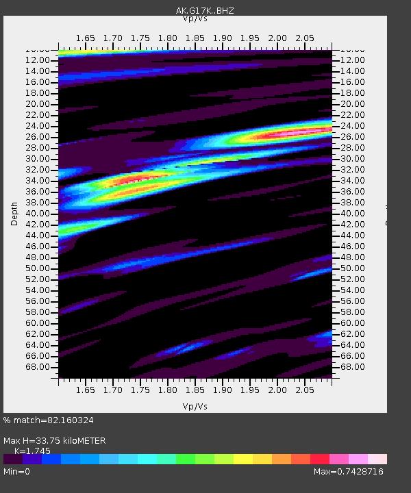
| Estimated Moho Depth: |
33.75 km |
| Estimated Crust Vp/Vs: |
1.75 |
| Assumed Crust Vp: |
6.276 km/s |
| Estimated Crust Vs: |
3.596 km/s |
| Estimated Crust Poisson's Ratio: |
0.26 |
|
| Radial Match: |
82.160324 % |
| Radial Bump: |
400 |
| Transverse Match: |
72.99888 % |
| Transverse Bump: |
400 |
| SOD ConfigId: |
22732711 |
| Insert Time: |
2020-10-15 01:19:13.928 +0000 |
| GWidth: |
2.5 |
| Max Bumps: |
400 |
| Tol: |
0.001 |
|

Signal To Noise
| Channel | StoN | STA | LTA |
| AK:G17K: :BHZ:20201001T01:25:42.559998Z | 18.120811 | 2.2126358E-6 | 1.2210468E-7 |
| AK:G17K: :BHN:20201001T01:25:42.559998Z | 2.8402147 | 6.827448E-7 | 2.4038494E-7 |
| AK:G17K: :BHE:20201001T01:25:42.559998Z | 3.0498753 | 5.610103E-7 | 1.8394532E-7 |
| Arrivals |
| Ps | 4.1 SECOND |
| PpPs | 14 SECOND |
| PsPs/PpSs | 19 SECOND |


