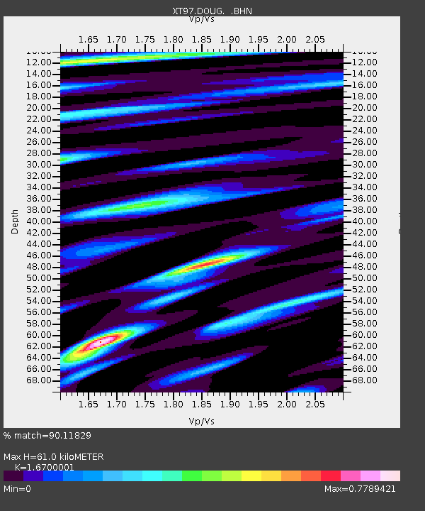
DOUG XT.DOUG - Earthquake Result Viewer

Earthquake location: Near Coast Of Central Chile
Earthquake latitude/longitude: -30.9/-71.2
Earthquake time(UTC): 1997/10/15 (288) 01:03:33 GMT
Earthquake Depth: 58 km
Earthquake Magnitude: 6.8 MB, 6.8 MS, 7.3 UNKNOWN, 7.1 MW
Earthquake Catalog/Contributor: WHDF/NEIC
Network: XT Colorado BB Array - Lodore
Station: DOUG XT.DOUG
Lat/Lon: 40.57 N/108.69 W
Elevation: 2153 m
Distance: 79.2 deg
Az: 331.847 deg
Baz: 147.844 deg
Ray Param: 0.04904295
Estimated Moho Depth: 61.0 km
Estimated Crust Vp/Vs: 1.67
Assumed Crust Vp: 6.207 km/s
Estimated Crust Vs: 3.717 km/s
Estimated Crust Poisson's Ratio: 0.22
Radial Match: 90.11829 %
Radial Bump: 400
Transverse Match: 76.63269 %
Transverse Bump: 400
SOD ConfigId: 6273
Insert Time: 2010-03-09 01:30:12.434 +0000
GWidth: 2.5
Max Bumps: 400
Tol: 0.001

Signal To Noise

ChannelStoNSTALTA
XT:DOUG: :BHN:19971015T01:15:00.925024Z2.84259133.820728E-71.3441004E-7
XT:DOUG: :BHE:19971015T01:15:00.925024Z3.35287054.2866677E-71.2785068E-7
XT:DOUG: :BHZ:19971015T01:15:00.925024Z7.0563751.2288018E-61.7414065E-7
Arrivals
Ps6.8 SECOND
PpPs25 SECOND
PsPs/PpSs32 SECOND