You are here: Home > Network List > GS - US Geological Survey Networks Stations List
> Station ASL9 Albuquerque, New Mexico, USA > Earthquake Result Viewer
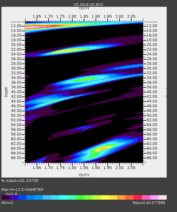
ASL9 Albuquerque, New Mexico, USA - Earthquake Result Viewer
| Earthquake location: |
Fiji Islands Region |
| Earthquake latitude/longitude: |
-18.0/-178.9 |
| Earthquake time(UTC): |
2017/08/19 (231) 02:00:52 GMT |
| Earthquake Depth: |
539 km |
| Earthquake Magnitude: |
6.4 Mww |
| Earthquake Catalog/Contributor: |
NEIC PDE/us |
|
| Network: |
GS US Geological Survey Networks |
| Station: |
ASL9 Albuquerque, New Mexico, USA |
| Lat/Lon: |
34.95 N/106.46 W |
| Elevation: |
1820 m |
|
| Distance: |
86.5 deg |
| Az: |
51.675 deg |
| Baz: |
245.366 deg |
| Ray Param: |
0.04251478 |
| Estimated Moho Depth: |
12.5 km |
| Estimated Crust Vp/Vs: |
1.60 |
| Assumed Crust Vp: |
6.502 km/s |
| Estimated Crust Vs: |
4.063 km/s |
| Estimated Crust Poisson's Ratio: |
0.18 |
|
| Radial Match: |
81.43729 % |
| Radial Bump: |
400 |
| Transverse Match: |
68.99778 % |
| Transverse Bump: |
400 |
| SOD ConfigId: |
2140511 |
| Insert Time: |
2017-09-01 17:58:31.034 +0000 |
| GWidth: |
2.5 |
| Max Bumps: |
400 |
| Tol: |
0.001 |
|

Signal To Noise
| Channel | StoN | STA | LTA |
| GS:ASL9:00:BHZ:20170819T02:12:06.344016Z | 8.569202 | 8.452992E-7 | 9.864385E-8 |
| GS:ASL9:00:BH1:20170819T02:12:06.344016Z | 3.4111369 | 2.223633E-7 | 6.518744E-8 |
| GS:ASL9:00:BH2:20170819T02:12:06.344016Z | 4.8846827 | 1.9681778E-7 | 4.0292846E-8 |
| Arrivals |
| Ps | 1.2 SECOND |
| PpPs | 4.9 SECOND |
| PsPs/PpSs | 6.1 SECOND |


