You are here: Home > Network List > GS - US Geological Survey Networks Stations List
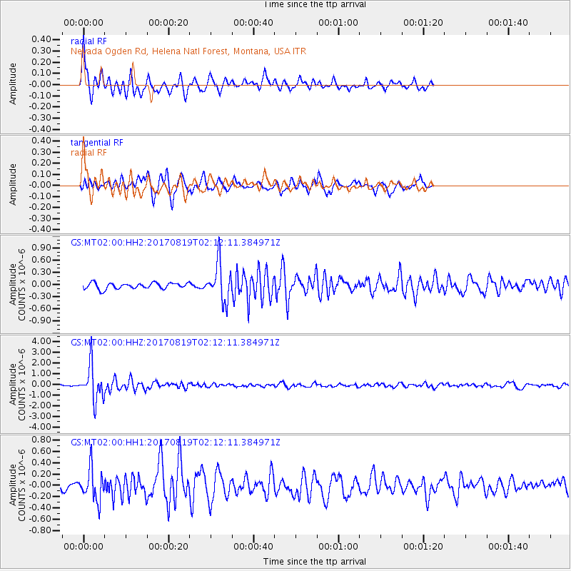
> Station MT02 Nevada Ogden Rd, Helena Natl Forest, Montana, USA > Earthquake Result Viewer
MT02 Nevada Ogden Rd, Helena Natl Forest, Montana, USA - Earthquake Result Viewer
| Earthquake location: |
Fiji Islands Region |
| Earthquake latitude/longitude: |
-18.0/-178.9 |
| Earthquake time(UTC): |
2017/08/19 (231) 02:00:52 GMT |
| Earthquake Depth: |
539 km |
| Earthquake Magnitude: |
6.4 Mww |
| Earthquake Catalog/Contributor: |
NEIC PDE/us |
|
| Network: |
GS US Geological Survey Networks |
| Station: |
MT02 Nevada Ogden Rd, Helena Natl Forest, Montana, USA |
| Lat/Lon: |
46.86 N/112.88 W |
| Elevation: |
1672 m |
|
| Distance: |
87.5 deg |
| Az: |
38.855 deg |
| Baz: |
240.477 deg |
| Ray Param: |
0.041757796 |
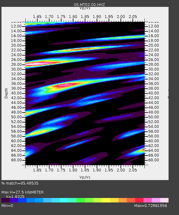
| Estimated Moho Depth: |
27.5 km |
| Estimated Crust Vp/Vs: |
1.63 |
| Assumed Crust Vp: |
6.353 km/s |
| Estimated Crust Vs: |
3.892 km/s |
| Estimated Crust Poisson's Ratio: |
0.20 |
|
| Radial Match: |
85.49535 % |
| Radial Bump: |
400 |
| Transverse Match: |
76.76296 % |
| Transverse Bump: |
400 |
| SOD ConfigId: |
2140511 |
| Insert Time: |
2017-09-01 17:58:36.292 +0000 |
| GWidth: |
2.5 |
| Max Bumps: |
400 |
| Tol: |
0.001 |
|
Signal To Noise
| Channel | StoN | STA | LTA |
| GS:MT02:00:HHZ:20170819T02:12:11.384971Z | 29.909899 | 1.6809753E-6 | 5.62013E-8 |
| GS:MT02:00:HH1:20170819T02:12:11.384971Z | 3.8512015 | 2.9094812E-7 | 7.554736E-8 |
| GS:MT02:00:HH2:20170819T02:12:11.384971Z | 6.517442 | 4.762468E-7 | 7.3072655E-8 |
| Arrivals |
| Ps | 2.8 SECOND |
| PpPs | 11 SECOND |
| PsPs/PpSs | 14 SECOND |


