You are here: Home > Network List > IU - Global Seismograph Network (GSN - IRIS/USGS) Stations List
> Station JOHN Johnston Island, USA > Earthquake Result Viewer
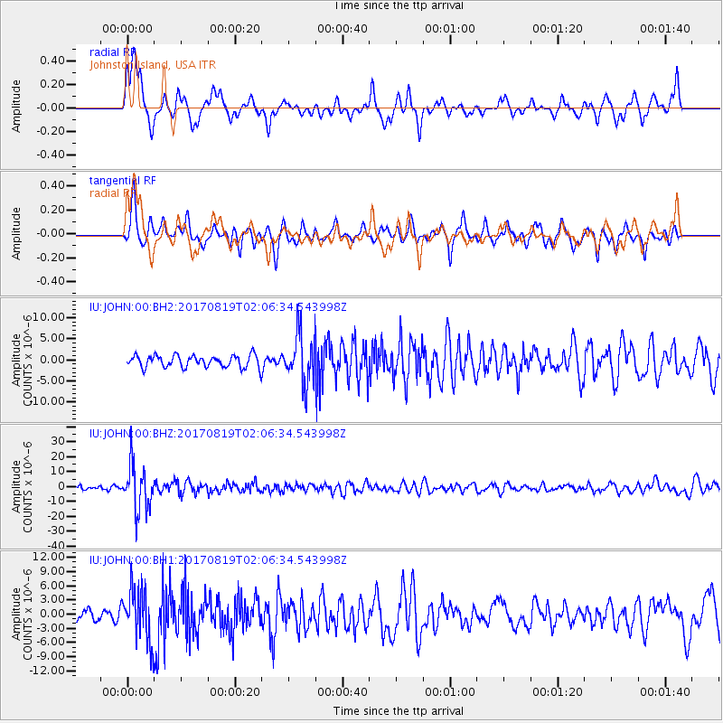
JOHN Johnston Island, USA - Earthquake Result Viewer
*The percent match for this event was below the threshold and hence no stack was calculated.
| Earthquake location: |
Fiji Islands Region |
| Earthquake latitude/longitude: |
-18.0/-178.9 |
| Earthquake time(UTC): |
2017/08/19 (231) 02:00:52 GMT |
| Earthquake Depth: |
539 km |
| Earthquake Magnitude: |
6.4 Mww |
| Earthquake Catalog/Contributor: |
NEIC PDE/us |
|
| Network: |
IU Global Seismograph Network (GSN - IRIS/USGS) |
| Station: |
JOHN Johnston Island, USA |
| Lat/Lon: |
16.73 N/169.53 W |
| Elevation: |
2.0 m |
|
| Distance: |
35.7 deg |
| Az: |
15.431 deg |
| Baz: |
195.327 deg |
| Ray Param: |
$rayparam |
*The percent match for this event was below the threshold and hence was not used in the summary stack. |
|
| Radial Match: |
74.12104 % |
| Radial Bump: |
400 |
| Transverse Match: |
77.84589 % |
| Transverse Bump: |
359 |
| SOD ConfigId: |
2140511 |
| Insert Time: |
2017-09-01 17:59:09.183 +0000 |
| GWidth: |
2.5 |
| Max Bumps: |
400 |
| Tol: |
0.001 |
|
Signal To Noise
| Channel | StoN | STA | LTA |
| IU:JOHN:00:BHZ:20170819T02:06:34.543998Z | 10.580509 | 1.573287E-5 | 1.4869672E-6 |
| IU:JOHN:00:BH1:20170819T02:06:34.543998Z | 3.773611 | 5.536442E-6 | 1.4671471E-6 |
| IU:JOHN:00:BH2:20170819T02:06:34.543998Z | 4.1575694 | 5.939412E-6 | 1.428578E-6 |
| Arrivals |
| Ps | |
| PpPs | |
| PsPs/PpSs | |


