You are here: Home > Network List > CI - Caltech Regional Seismic Network Stations List
> Station VTV Victorville, California, USA > Earthquake Result Viewer
VTV Victorville, California, USA - Earthquake Result Viewer
| Earthquake location: |
Tonga Islands |
| Earthquake latitude/longitude: |
-19.1/-173.6 |
| Earthquake time(UTC): |
2020/10/01 (275) 01:13:39 GMT |
| Earthquake Depth: |
10 km |
| Earthquake Magnitude: |
6.7 Mi |
| Earthquake Catalog/Contributor: |
NEIC PDE/at |
|
| Network: |
CI Caltech Regional Seismic Network |
| Station: |
VTV Victorville, California, USA |
| Lat/Lon: |
34.56 N/117.33 W |
| Elevation: |
812 m |
|
| Distance: |
75.5 deg |
| Az: |
45.139 deg |
| Baz: |
234.308 deg |
| Ray Param: |
0.05160675 |
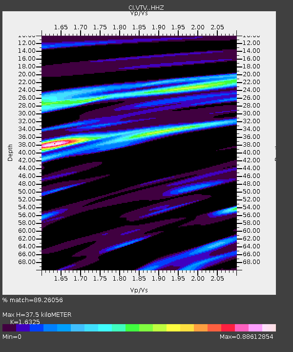
| Estimated Moho Depth: |
37.5 km |
| Estimated Crust Vp/Vs: |
1.63 |
| Assumed Crust Vp: |
6.276 km/s |
| Estimated Crust Vs: |
3.844 km/s |
| Estimated Crust Poisson's Ratio: |
0.20 |
|
| Radial Match: |
89.26056 % |
| Radial Bump: |
324 |
| Transverse Match: |
80.33771 % |
| Transverse Bump: |
384 |
| SOD ConfigId: |
22732711 |
| Insert Time: |
2020-10-15 01:27:21.387 +0000 |
| GWidth: |
2.5 |
| Max Bumps: |
400 |
| Tol: |
0.001 |
|

Signal To Noise
| Channel | StoN | STA | LTA |
| CI:VTV: :HHZ:20201001T01:24:52.257996Z | 16.413046 | 3.4691632E-6 | 2.113662E-7 |
| CI:VTV: :HHN:20201001T01:24:52.257996Z | 2.3720095 | 6.09469E-7 | 2.5694206E-7 |
| CI:VTV: :HHE:20201001T01:24:52.257996Z | 4.60725 | 1.2670846E-6 | 2.7501972E-7 |
| Arrivals |
| Ps | 3.9 SECOND |
| PpPs | 15 SECOND |
| PsPs/PpSs | 19 SECOND |


