You are here: Home > Network List > GS - US Geological Survey Networks Stations List
> Station ASA2 ASA2 > Earthquake Result Viewer
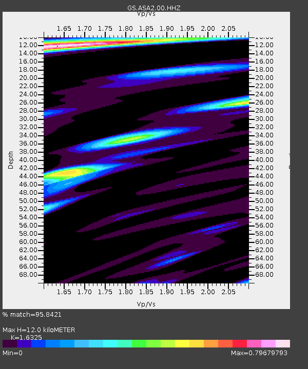
ASA2 ASA2 - Earthquake Result Viewer
| Earthquake location: |
Tonga Islands |
| Earthquake latitude/longitude: |
-19.1/-173.6 |
| Earthquake time(UTC): |
2020/10/01 (275) 01:13:39 GMT |
| Earthquake Depth: |
10 km |
| Earthquake Magnitude: |
6.7 Mi |
| Earthquake Catalog/Contributor: |
NEIC PDE/at |
|
| Network: |
GS US Geological Survey Networks |
| Station: |
ASA2 ASA2 |
| Lat/Lon: |
34.95 N/106.46 W |
| Elevation: |
1830 m |
|
| Distance: |
83.3 deg |
| Az: |
49.654 deg |
| Baz: |
241.319 deg |
| Ray Param: |
0.04627534 |
| Estimated Moho Depth: |
12.0 km |
| Estimated Crust Vp/Vs: |
1.63 |
| Assumed Crust Vp: |
6.502 km/s |
| Estimated Crust Vs: |
3.983 km/s |
| Estimated Crust Poisson's Ratio: |
0.20 |
|
| Radial Match: |
95.8421 % |
| Radial Bump: |
400 |
| Transverse Match: |
91.769905 % |
| Transverse Bump: |
400 |
| SOD ConfigId: |
22732711 |
| Insert Time: |
2020-10-15 01:29:51.094 +0000 |
| GWidth: |
2.5 |
| Max Bumps: |
400 |
| Tol: |
0.001 |
|

Signal To Noise
| Channel | StoN | STA | LTA |
| GS:ASA2:00:HHZ:20201001T01:25:34.479004Z | 52.71693 | 5.7006782E-6 | 1.0813752E-7 |
| GS:ASA2:00:HH1:20201001T01:25:34.479004Z | 8.570296 | 1.1186546E-6 | 1.3052694E-7 |
| GS:ASA2:00:HH2:20201001T01:25:34.479004Z | 23.74418 | 1.6897695E-6 | 7.116563E-8 |
| Arrivals |
| Ps | 1.2 SECOND |
| PpPs | 4.7 SECOND |
| PsPs/PpSs | 5.9 SECOND |


