You are here: Home > Network List > IW - Intermountain West Stations List
> Station DLMT Dillon, Montana, USA > Earthquake Result Viewer
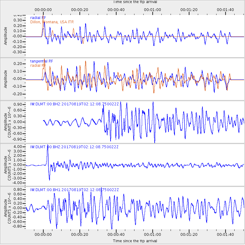
DLMT Dillon, Montana, USA - Earthquake Result Viewer
*The percent match for this event was below the threshold and hence no stack was calculated.
| Earthquake location: |
Fiji Islands Region |
| Earthquake latitude/longitude: |
-18.0/-178.9 |
| Earthquake time(UTC): |
2017/08/19 (231) 02:00:52 GMT |
| Earthquake Depth: |
539 km |
| Earthquake Magnitude: |
6.4 Mww |
| Earthquake Catalog/Contributor: |
NEIC PDE/us |
|
| Network: |
IW Intermountain West |
| Station: |
DLMT Dillon, Montana, USA |
| Lat/Lon: |
45.36 N/112.60 W |
| Elevation: |
1569 m |
|
| Distance: |
87.0 deg |
| Az: |
40.257 deg |
| Baz: |
240.748 deg |
| Ray Param: |
$rayparam |
*The percent match for this event was below the threshold and hence was not used in the summary stack. |
|
| Radial Match: |
74.62295 % |
| Radial Bump: |
400 |
| Transverse Match: |
78.002365 % |
| Transverse Bump: |
362 |
| SOD ConfigId: |
2140511 |
| Insert Time: |
2017-09-01 17:59:39.035 +0000 |
| GWidth: |
2.5 |
| Max Bumps: |
400 |
| Tol: |
0.001 |
|
Signal To Noise
| Channel | StoN | STA | LTA |
| IW:DLMT:00:BHZ:20170819T02:12:08.750022Z | 22.687489 | 1.6441375E-6 | 7.246891E-8 |
| IW:DLMT:00:BH1:20170819T02:12:08.750022Z | 2.2103193 | 2.3953078E-7 | 1.0836931E-7 |
| IW:DLMT:00:BH2:20170819T02:12:08.750022Z | 3.0284786 | 3.2890011E-7 | 1.0860243E-7 |
| Arrivals |
| Ps | |
| PpPs | |
| PsPs/PpSs | |


