You are here: Home > Network List > NN - Western Great Basin/Eastern Sierra Nevada Stations List
> Station WLDB Wildcat Mountain, NV, USA analog reactivation > Earthquake Result Viewer
WLDB Wildcat Mountain, NV, USA analog reactivation - Earthquake Result Viewer
| Earthquake location: |
Tonga Islands |
| Earthquake latitude/longitude: |
-19.1/-173.6 |
| Earthquake time(UTC): |
2020/10/01 (275) 01:13:39 GMT |
| Earthquake Depth: |
10 km |
| Earthquake Magnitude: |
6.7 Mi |
| Earthquake Catalog/Contributor: |
NEIC PDE/at |
|
| Network: |
NN Western Great Basin/Eastern Sierra Nevada |
| Station: |
WLDB Wildcat Mountain, NV, USA analog reactivation |
| Lat/Lon: |
36.79 N/116.63 W |
| Elevation: |
955 m |
|
| Distance: |
77.3 deg |
| Az: |
43.621 deg |
| Baz: |
234.36 deg |
| Ray Param: |
0.0504135 |
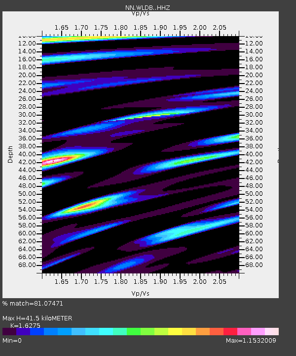
| Estimated Moho Depth: |
41.5 km |
| Estimated Crust Vp/Vs: |
1.63 |
| Assumed Crust Vp: |
6.279 km/s |
| Estimated Crust Vs: |
3.858 km/s |
| Estimated Crust Poisson's Ratio: |
0.20 |
|
| Radial Match: |
81.07471 % |
| Radial Bump: |
400 |
| Transverse Match: |
61.097496 % |
| Transverse Bump: |
400 |
| SOD ConfigId: |
22732711 |
| Insert Time: |
2020-10-15 01:34:33.104 +0000 |
| GWidth: |
2.5 |
| Max Bumps: |
400 |
| Tol: |
0.001 |
|

Signal To Noise
| Channel | StoN | STA | LTA |
| NN:WLDB: :HHZ:20201001T01:25:02.22998Z | 19.607956 | 3.1283812E-6 | 1.5954653E-7 |
| NN:WLDB: :HHN:20201001T01:25:02.22998Z | 4.467656 | 6.4678636E-7 | 1.4477084E-7 |
| NN:WLDB: :HHE:20201001T01:25:02.22998Z | 3.6112359 | 8.568842E-7 | 2.3728282E-7 |
| Arrivals |
| Ps | 4.3 SECOND |
| PpPs | 17 SECOND |
| PsPs/PpSs | 21 SECOND |


