You are here: Home > Network List > O2 - Oklahoma Consolidated Temporary Seismic Networks Stations List
> Station FW09 Waynoka, Oklahoma, USA > Earthquake Result Viewer
FW09 Waynoka, Oklahoma, USA - Earthquake Result Viewer
| Earthquake location: |
Tonga Islands |
| Earthquake latitude/longitude: |
-19.1/-173.6 |
| Earthquake time(UTC): |
2020/10/01 (275) 01:13:39 GMT |
| Earthquake Depth: |
10 km |
| Earthquake Magnitude: |
6.7 Mi |
| Earthquake Catalog/Contributor: |
NEIC PDE/at |
|
| Network: |
O2 Oklahoma Consolidated Temporary Seismic Networks |
| Station: |
FW09 Waynoka, Oklahoma, USA |
| Lat/Lon: |
36.55 N/99.04 W |
| Elevation: |
517 m |
|
| Distance: |
89.4 deg |
| Az: |
50.915 deg |
| Baz: |
245.719 deg |
| Ray Param: |
0.041855406 |
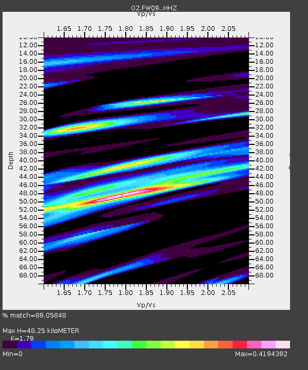
| Estimated Moho Depth: |
48.25 km |
| Estimated Crust Vp/Vs: |
1.79 |
| Assumed Crust Vp: |
6.426 km/s |
| Estimated Crust Vs: |
3.59 km/s |
| Estimated Crust Poisson's Ratio: |
0.27 |
|
| Radial Match: |
89.05848 % |
| Radial Bump: |
335 |
| Transverse Match: |
89.0585 % |
| Transverse Bump: |
335 |
| SOD ConfigId: |
22732711 |
| Insert Time: |
2020-10-15 01:35:33.597 +0000 |
| GWidth: |
2.5 |
| Max Bumps: |
400 |
| Tol: |
0.001 |
|

Signal To Noise
| Channel | StoN | STA | LTA |
| O2:FW09: :HHZ:20201001T01:26:04.39502Z | 18.65416 | 3.5464398E-6 | 1.9011522E-7 |
| $trig.getChannelId() | $trig.getValue() | $trig.getSTA() | $trig.getLTA() |
| O2:FW09: :HHE:20201001T01:26:04.39502Z | 4.376604 | 9.5059653E-7 | 2.1719956E-7 |
| Arrivals |
| Ps | 6.1 SECOND |
| PpPs | 21 SECOND |
| PsPs/PpSs | 27 SECOND |


