You are here: Home > Network List > O2 - Oklahoma Consolidated Temporary Seismic Networks Stations List
> Station GORE Near Medford, Oklahoma, USA > Earthquake Result Viewer
GORE Near Medford, Oklahoma, USA - Earthquake Result Viewer
| Earthquake location: |
Tonga Islands |
| Earthquake latitude/longitude: |
-19.1/-173.6 |
| Earthquake time(UTC): |
2020/10/01 (275) 01:13:39 GMT |
| Earthquake Depth: |
10 km |
| Earthquake Magnitude: |
6.7 Mi |
| Earthquake Catalog/Contributor: |
NEIC PDE/at |
|
| Network: |
O2 Oklahoma Consolidated Temporary Seismic Networks |
| Station: |
GORE Near Medford, Oklahoma, USA |
| Lat/Lon: |
36.79 N/97.95 W |
| Elevation: |
348 m |
|
| Distance: |
90.3 deg |
| Az: |
51.058 deg |
| Baz: |
246.369 deg |
| Ray Param: |
0.041710403 |
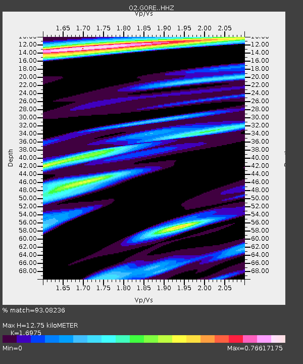
| Estimated Moho Depth: |
12.75 km |
| Estimated Crust Vp/Vs: |
1.70 |
| Assumed Crust Vp: |
6.483 km/s |
| Estimated Crust Vs: |
3.819 km/s |
| Estimated Crust Poisson's Ratio: |
0.23 |
|
| Radial Match: |
93.08236 % |
| Radial Bump: |
327 |
| Transverse Match: |
66.213806 % |
| Transverse Bump: |
368 |
| SOD ConfigId: |
22732711 |
| Insert Time: |
2020-10-15 01:35:36.238 +0000 |
| GWidth: |
2.5 |
| Max Bumps: |
400 |
| Tol: |
0.001 |
|

Signal To Noise
| Channel | StoN | STA | LTA |
| O2:GORE: :HHZ:20201001T01:26:08.559998Z | 25.49907 | 3.0636884E-6 | 1.2014902E-7 |
| O2:GORE: :HHN:20201001T01:26:08.559998Z | 2.7247677 | 4.8509986E-7 | 1.7803346E-7 |
| O2:GORE: :HHE:20201001T01:26:08.559998Z | 5.9016314 | 1.0002757E-6 | 1.694914E-7 |
| Arrivals |
| Ps | 1.4 SECOND |
| PpPs | 5.2 SECOND |
| PsPs/PpSs | 6.6 SECOND |


