You are here: Home > Network List > US - United States National Seismic Network Stations List
> Station AMTX Amarillo, Texas, USA > Earthquake Result Viewer
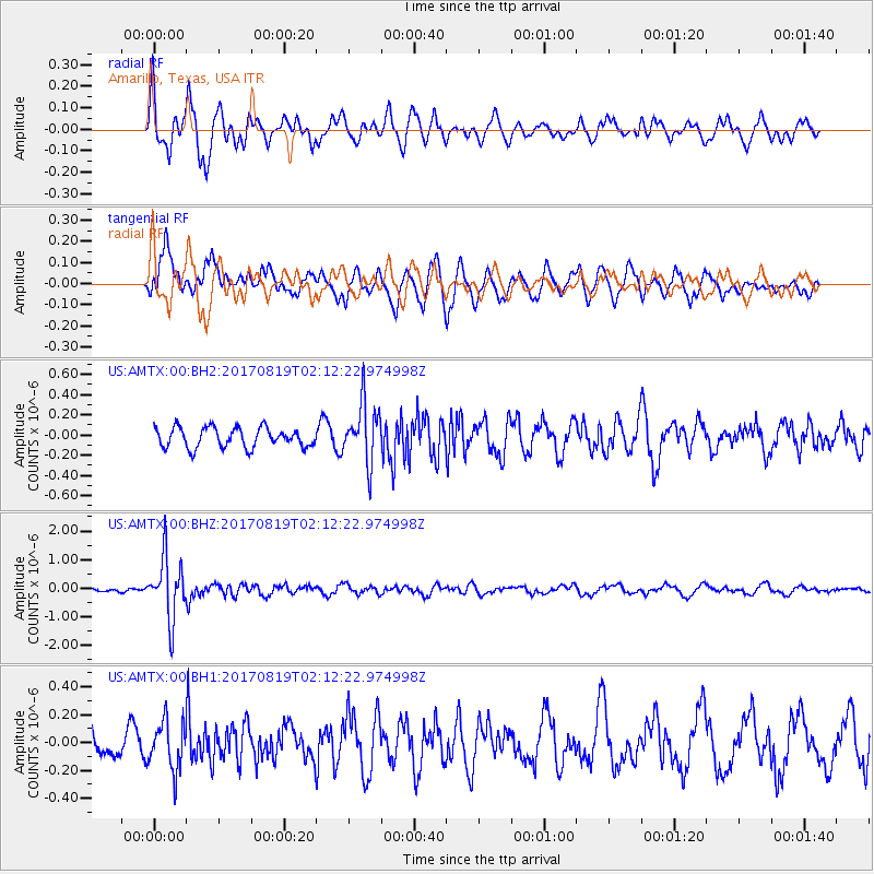
AMTX Amarillo, Texas, USA - Earthquake Result Viewer
*The percent match for this event was below the threshold and hence no stack was calculated.
| Earthquake location: |
Fiji Islands Region |
| Earthquake latitude/longitude: |
-18.0/-178.9 |
| Earthquake time(UTC): |
2017/08/19 (231) 02:00:52 GMT |
| Earthquake Depth: |
539 km |
| Earthquake Magnitude: |
6.4 Mww |
| Earthquake Catalog/Contributor: |
NEIC PDE/us |
|
| Network: |
US United States National Seismic Network |
| Station: |
AMTX Amarillo, Texas, USA |
| Lat/Lon: |
34.53 N/101.41 W |
| Elevation: |
1010 m |
|
| Distance: |
90.1 deg |
| Az: |
53.692 deg |
| Baz: |
248.291 deg |
| Ray Param: |
$rayparam |
*The percent match for this event was below the threshold and hence was not used in the summary stack. |
|
| Radial Match: |
75.28327 % |
| Radial Bump: |
400 |
| Transverse Match: |
74.53331 % |
| Transverse Bump: |
400 |
| SOD ConfigId: |
2140511 |
| Insert Time: |
2017-09-01 18:00:21.224 +0000 |
| GWidth: |
2.5 |
| Max Bumps: |
400 |
| Tol: |
0.001 |
|
Signal To Noise
| Channel | StoN | STA | LTA |
| US:AMTX:00:BHZ:20170819T02:12:22.974998Z | 8.286789 | 1.0657126E-6 | 1.2860379E-7 |
| US:AMTX:00:BH1:20170819T02:12:22.974998Z | 1.7890166 | 1.7385047E-7 | 9.717655E-8 |
| US:AMTX:00:BH2:20170819T02:12:22.974998Z | 3.0507061 | 2.9477798E-7 | 9.6626145E-8 |
| Arrivals |
| Ps | |
| PpPs | |
| PsPs/PpSs | |


