You are here: Home > Network List > O2 - Oklahoma Consolidated Temporary Seismic Networks Stations List
> Station PW15 Ralston, Oklahoma, USA > Earthquake Result Viewer
PW15 Ralston, Oklahoma, USA - Earthquake Result Viewer
| Earthquake location: |
Tonga Islands |
| Earthquake latitude/longitude: |
-19.1/-173.6 |
| Earthquake time(UTC): |
2020/10/01 (275) 01:13:39 GMT |
| Earthquake Depth: |
10 km |
| Earthquake Magnitude: |
6.7 Mi |
| Earthquake Catalog/Contributor: |
NEIC PDE/at |
|
| Network: |
O2 Oklahoma Consolidated Temporary Seismic Networks |
| Station: |
PW15 Ralston, Oklahoma, USA |
| Lat/Lon: |
36.47 N/97.01 W |
| Elevation: |
270 m |
|
| Distance: |
90.9 deg |
| Az: |
51.646 deg |
| Baz: |
246.917 deg |
| Ray Param: |
0.041666787 |
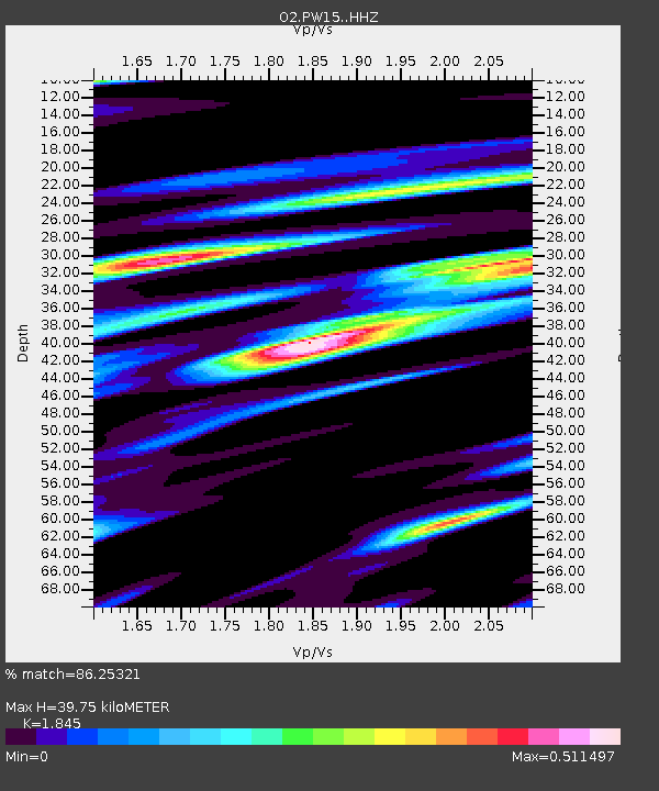
| Estimated Moho Depth: |
39.75 km |
| Estimated Crust Vp/Vs: |
1.85 |
| Assumed Crust Vp: |
6.483 km/s |
| Estimated Crust Vs: |
3.514 km/s |
| Estimated Crust Poisson's Ratio: |
0.29 |
|
| Radial Match: |
86.25321 % |
| Radial Bump: |
319 |
| Transverse Match: |
71.51288 % |
| Transverse Bump: |
400 |
| SOD ConfigId: |
22732711 |
| Insert Time: |
2020-10-15 01:35:55.974 +0000 |
| GWidth: |
2.5 |
| Max Bumps: |
400 |
| Tol: |
0.001 |
|

Signal To Noise
| Channel | StoN | STA | LTA |
| O2:PW15: :HHZ:20201001T01:26:11.174988Z | 19.091434 | 2.613014E-6 | 1.368684E-7 |
| O2:PW15: :HHN:20201001T01:26:11.174988Z | 2.0300364 | 4.2206636E-7 | 2.0791074E-7 |
| O2:PW15: :HHE:20201001T01:26:11.174988Z | 5.6633725 | 9.552551E-7 | 1.686725E-7 |
| Arrivals |
| Ps | 5.3 SECOND |
| PpPs | 17 SECOND |
| PsPs/PpSs | 22 SECOND |


