You are here: Home > Network List > O2 - Oklahoma Consolidated Temporary Seismic Networks Stations List
> Station SC19 Bison, Oklahoma, USA > Earthquake Result Viewer
SC19 Bison, Oklahoma, USA - Earthquake Result Viewer
| Earthquake location: |
Tonga Islands |
| Earthquake latitude/longitude: |
-19.1/-173.6 |
| Earthquake time(UTC): |
2020/10/01 (275) 01:13:39 GMT |
| Earthquake Depth: |
10 km |
| Earthquake Magnitude: |
6.7 Mi |
| Earthquake Catalog/Contributor: |
NEIC PDE/at |
|
| Network: |
O2 Oklahoma Consolidated Temporary Seismic Networks |
| Station: |
SC19 Bison, Oklahoma, USA |
| Lat/Lon: |
36.22 N/97.84 W |
| Elevation: |
1116 m |
|
| Distance: |
90.2 deg |
| Az: |
51.608 deg |
| Baz: |
246.428 deg |
| Ray Param: |
0.041718412 |
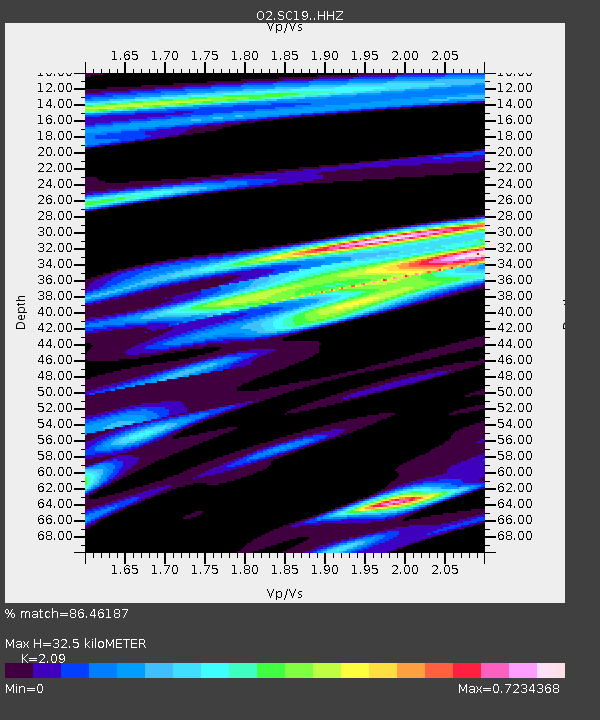
| Estimated Moho Depth: |
32.5 km |
| Estimated Crust Vp/Vs: |
2.09 |
| Assumed Crust Vp: |
6.483 km/s |
| Estimated Crust Vs: |
3.102 km/s |
| Estimated Crust Poisson's Ratio: |
0.35 |
|
| Radial Match: |
86.46187 % |
| Radial Bump: |
353 |
| Transverse Match: |
61.60233 % |
| Transverse Bump: |
400 |
| SOD ConfigId: |
22732711 |
| Insert Time: |
2020-10-15 01:36:26.835 +0000 |
| GWidth: |
2.5 |
| Max Bumps: |
400 |
| Tol: |
0.001 |
|

Signal To Noise
| Channel | StoN | STA | LTA |
| O2:SC19: :HHZ:20201001T01:26:07.875Z | 10.71775 | 2.4768296E-6 | 2.3109607E-7 |
| O2:SC19: :HHN:20201001T01:26:07.875Z | 0.9580639 | 1.9892587E-7 | 2.076332E-7 |
| O2:SC19: :HHE:20201001T01:26:07.875Z | 6.6368327 | 1.0958877E-6 | 1.6512209E-7 |
| Arrivals |
| Ps | 5.6 SECOND |
| PpPs | 15 SECOND |
| PsPs/PpSs | 21 SECOND |


