You are here: Home > Network List > RV - Regional Alberta Seismic Observatory for Earthquake Studies Network Stations List
> Station DEDWA Deadwood Lookout Tower, AB > Earthquake Result Viewer
DEDWA Deadwood Lookout Tower, AB - Earthquake Result Viewer
| Earthquake location: |
Tonga Islands |
| Earthquake latitude/longitude: |
-19.1/-173.6 |
| Earthquake time(UTC): |
2020/10/01 (275) 01:13:39 GMT |
| Earthquake Depth: |
10 km |
| Earthquake Magnitude: |
6.7 Mi |
| Earthquake Catalog/Contributor: |
NEIC PDE/at |
|
| Network: |
RV Regional Alberta Seismic Observatory for Earthquake Studies Network |
| Station: |
DEDWA Deadwood Lookout Tower, AB |
| Lat/Lon: |
56.64 N/117.39 W |
| Elevation: |
652 m |
|
| Distance: |
88.9 deg |
| Az: |
27.335 deg |
| Baz: |
231.818 deg |
| Ray Param: |
0.042252675 |
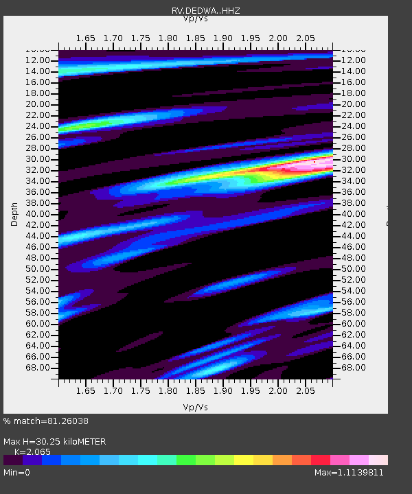
| Estimated Moho Depth: |
30.25 km |
| Estimated Crust Vp/Vs: |
2.07 |
| Assumed Crust Vp: |
6.444 km/s |
| Estimated Crust Vs: |
3.121 km/s |
| Estimated Crust Poisson's Ratio: |
0.35 |
|
| Radial Match: |
81.26038 % |
| Radial Bump: |
400 |
| Transverse Match: |
51.458023 % |
| Transverse Bump: |
400 |
| SOD ConfigId: |
22732711 |
| Insert Time: |
2020-10-15 01:38:11.051 +0000 |
| GWidth: |
2.5 |
| Max Bumps: |
400 |
| Tol: |
0.001 |
|

Signal To Noise
| Channel | StoN | STA | LTA |
| RV:DEDWA: :HHZ:20201001T01:26:01.849976Z | 22.170061 | 5.5885944E-6 | 2.5207845E-7 |
| RV:DEDWA: :HHN:20201001T01:26:01.849976Z | 1.336632 | 1.4920369E-6 | 1.116266E-6 |
| RV:DEDWA: :HHE:20201001T01:26:01.849976Z | 2.3970044 | 1.7282779E-6 | 7.2101574E-7 |
| Arrivals |
| Ps | 5.1 SECOND |
| PpPs | 14 SECOND |
| PsPs/PpSs | 19 SECOND |


