You are here: Home > Network List > TA - USArray Transportable Network (new EarthScope stations) Stations List
> Station E17K Hotham Inlet, AK, USA > Earthquake Result Viewer
E17K Hotham Inlet, AK, USA - Earthquake Result Viewer
| Earthquake location: |
Tonga Islands |
| Earthquake latitude/longitude: |
-19.1/-173.6 |
| Earthquake time(UTC): |
2020/10/01 (275) 01:13:39 GMT |
| Earthquake Depth: |
10 km |
| Earthquake Magnitude: |
6.7 Mi |
| Earthquake Catalog/Contributor: |
NEIC PDE/at |
|
| Network: |
TA USArray Transportable Network (new EarthScope stations) |
| Station: |
E17K Hotham Inlet, AK, USA |
| Lat/Lon: |
67.08 N/161.83 W |
| Elevation: |
233 m |
|
| Distance: |
86.4 deg |
| Az: |
4.593 deg |
| Baz: |
191.148 deg |
| Ray Param: |
0.044100735 |
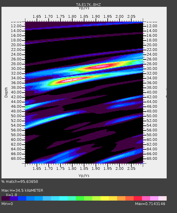
| Estimated Moho Depth: |
34.5 km |
| Estimated Crust Vp/Vs: |
1.80 |
| Assumed Crust Vp: |
6.276 km/s |
| Estimated Crust Vs: |
3.487 km/s |
| Estimated Crust Poisson's Ratio: |
0.28 |
|
| Radial Match: |
95.63658 % |
| Radial Bump: |
315 |
| Transverse Match: |
78.24607 % |
| Transverse Bump: |
400 |
| SOD ConfigId: |
22732711 |
| Insert Time: |
2020-10-15 01:39:23.414 +0000 |
| GWidth: |
2.5 |
| Max Bumps: |
400 |
| Tol: |
0.001 |
|

Signal To Noise
| Channel | StoN | STA | LTA |
| TA:E17K: :BHZ:20201001T01:25:49.799988Z | 11.232939 | 1.8124647E-6 | 1.6135267E-7 |
| TA:E17K: :BHN:20201001T01:25:49.799988Z | 3.8698497 | 6.4497425E-7 | 1.6666648E-7 |
| TA:E17K: :BHE:20201001T01:25:49.799988Z | 2.392712 | 3.729652E-7 | 1.558755E-7 |
| Arrivals |
| Ps | 4.5 SECOND |
| PpPs | 15 SECOND |
| PsPs/PpSs | 20 SECOND |


