You are here: Home > Network List > TA - USArray Transportable Network (new EarthScope stations) Stations List
> Station F17K Baldwin Penninsula, AK, USA > Earthquake Result Viewer
F17K Baldwin Penninsula, AK, USA - Earthquake Result Viewer
| Earthquake location: |
Tonga Islands |
| Earthquake latitude/longitude: |
-19.1/-173.6 |
| Earthquake time(UTC): |
2020/10/01 (275) 01:13:39 GMT |
| Earthquake Depth: |
10 km |
| Earthquake Magnitude: |
6.7 Mi |
| Earthquake Catalog/Contributor: |
NEIC PDE/at |
|
| Network: |
TA USArray Transportable Network (new EarthScope stations) |
| Station: |
F17K Baldwin Penninsula, AK, USA |
| Lat/Lon: |
66.44 N/161.25 W |
| Elevation: |
51 m |
|
| Distance: |
85.8 deg |
| Az: |
4.945 deg |
| Baz: |
191.701 deg |
| Ray Param: |
0.044514067 |
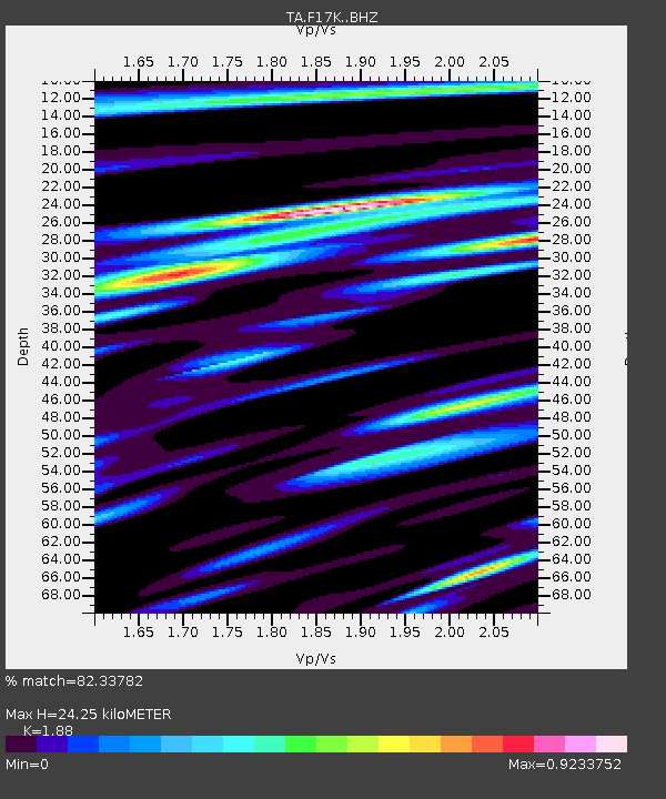
| Estimated Moho Depth: |
24.25 km |
| Estimated Crust Vp/Vs: |
1.88 |
| Assumed Crust Vp: |
6.276 km/s |
| Estimated Crust Vs: |
3.338 km/s |
| Estimated Crust Poisson's Ratio: |
0.30 |
|
| Radial Match: |
82.33782 % |
| Radial Bump: |
400 |
| Transverse Match: |
81.72526 % |
| Transverse Bump: |
400 |
| SOD ConfigId: |
22732711 |
| Insert Time: |
2020-10-15 01:39:34.149 +0000 |
| GWidth: |
2.5 |
| Max Bumps: |
400 |
| Tol: |
0.001 |
|

Signal To Noise
| Channel | StoN | STA | LTA |
| TA:F17K: :BHZ:20201001T01:25:46.924988Z | 13.857706 | 2.365009E-6 | 1.7066381E-7 |
| TA:F17K: :BHN:20201001T01:25:46.924988Z | 3.6205108 | 1.1211187E-6 | 3.096576E-7 |
| TA:F17K: :BHE:20201001T01:25:46.924988Z | 3.804732 | 1.0046343E-6 | 2.6404862E-7 |
| Arrivals |
| Ps | 3.5 SECOND |
| PpPs | 11 SECOND |
| PsPs/PpSs | 14 SECOND |


