You are here: Home > Network List > TA - USArray Transportable Network (new EarthScope stations) Stations List
> Station F31M Tsiigehtchic, NWT, CAN > Earthquake Result Viewer
F31M Tsiigehtchic, NWT, CAN - Earthquake Result Viewer
| Earthquake location: |
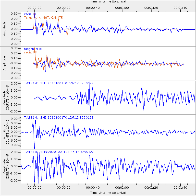
Tonga Islands |
| Earthquake latitude/longitude: |
-19.1/-173.6 |
| Earthquake time(UTC): |
2020/10/01 (275) 01:13:39 GMT |
| Earthquake Depth: |
10 km |
| Earthquake Magnitude: |
6.7 Mi |
| Earthquake Catalog/Contributor: |
NEIC PDE/at |
|
| Network: |
TA USArray Transportable Network (new EarthScope stations) |
| Station: |
F31M Tsiigehtchic, NWT, CAN |
| Lat/Lon: |
67.44 N/133.74 W |
| Elevation: |
56 m |
|
| Distance: |
91.1 deg |
| Az: |
14.319 deg |
| Baz: |
217.312 deg |
| Ray Param: |
0.041641463 |
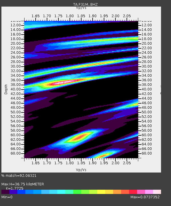
| Estimated Moho Depth: |
36.75 km |
| Estimated Crust Vp/Vs: |
1.77 |
| Assumed Crust Vp: |
6.171 km/s |
| Estimated Crust Vs: |
3.482 km/s |
| Estimated Crust Poisson's Ratio: |
0.27 |
|
| Radial Match: |
92.06321 % |
| Radial Bump: |
400 |
| Transverse Match: |
86.31912 % |
| Transverse Bump: |
357 |
| SOD ConfigId: |
22732711 |
| Insert Time: |
2020-10-15 01:39:45.887 +0000 |
| GWidth: |
2.5 |
| Max Bumps: |
400 |
| Tol: |
0.001 |
|
Signal To Noise
| Channel | StoN | STA | LTA |
| TA:F31M: :BHZ:20201001T01:26:12.325012Z | 19.56571 | 4.4424673E-6 | 2.2705373E-7 |
| TA:F31M: :BHN:20201001T01:26:12.325012Z | 5.6506047 | 1.2889956E-6 | 2.2811639E-7 |
| TA:F31M: :BHE:20201001T01:26:12.325012Z | 3.1865416 | 4.7640575E-7 | 1.4950558E-7 |
| Arrivals |
| Ps | 4.7 SECOND |
| PpPs | 16 SECOND |
| PsPs/PpSs | 21 SECOND |


