You are here: Home > Network List > TA - USArray Transportable Network (new EarthScope stations) Stations List
> Station G31M Satah River, YT, CAN > Earthquake Result Viewer
G31M Satah River, YT, CAN - Earthquake Result Viewer
| Earthquake location: |
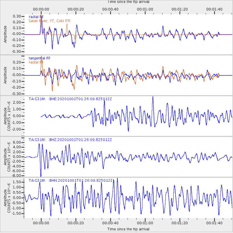
Tonga Islands |
| Earthquake latitude/longitude: |
-19.1/-173.6 |
| Earthquake time(UTC): |
2020/10/01 (275) 01:13:39 GMT |
| Earthquake Depth: |
10 km |
| Earthquake Magnitude: |
6.7 Mi |
| Earthquake Catalog/Contributor: |
NEIC PDE/at |
|
| Network: |
TA USArray Transportable Network (new EarthScope stations) |
| Station: |
G31M Satah River, YT, CAN |
| Lat/Lon: |
66.92 N/134.27 W |
| Elevation: |
61 m |
|
| Distance: |
90.6 deg |
| Az: |
14.469 deg |
| Baz: |
216.823 deg |
| Ray Param: |
0.04169184 |
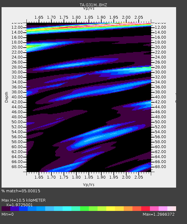
| Estimated Moho Depth: |
10.5 km |
| Estimated Crust Vp/Vs: |
1.97 |
| Assumed Crust Vp: |
6.171 km/s |
| Estimated Crust Vs: |
3.129 km/s |
| Estimated Crust Poisson's Ratio: |
0.33 |
|
| Radial Match: |
85.80815 % |
| Radial Bump: |
400 |
| Transverse Match: |
79.326744 % |
| Transverse Bump: |
400 |
| SOD ConfigId: |
22732711 |
| Insert Time: |
2020-10-15 01:39:58.484 +0000 |
| GWidth: |
2.5 |
| Max Bumps: |
400 |
| Tol: |
0.001 |
|
Signal To Noise
| Channel | StoN | STA | LTA |
| TA:G31M: :BHZ:20201001T01:26:09.825012Z | 22.962276 | 3.7708849E-6 | 1.6422086E-7 |
| TA:G31M: :BHN:20201001T01:26:09.825012Z | 2.2785337 | 6.884509E-7 | 3.0214645E-7 |
| TA:G31M: :BHE:20201001T01:26:09.825012Z | 4.9855857 | 7.271936E-7 | 1.458592E-7 |
| Arrivals |
| Ps | 1.7 SECOND |
| PpPs | 5.0 SECOND |
| PsPs/PpSs | 6.7 SECOND |


