You are here: Home > Network List > TA - USArray Transportable Network (new EarthScope stations) Stations List
> Station H31M Peel River, Yukon, CAN > Earthquake Result Viewer
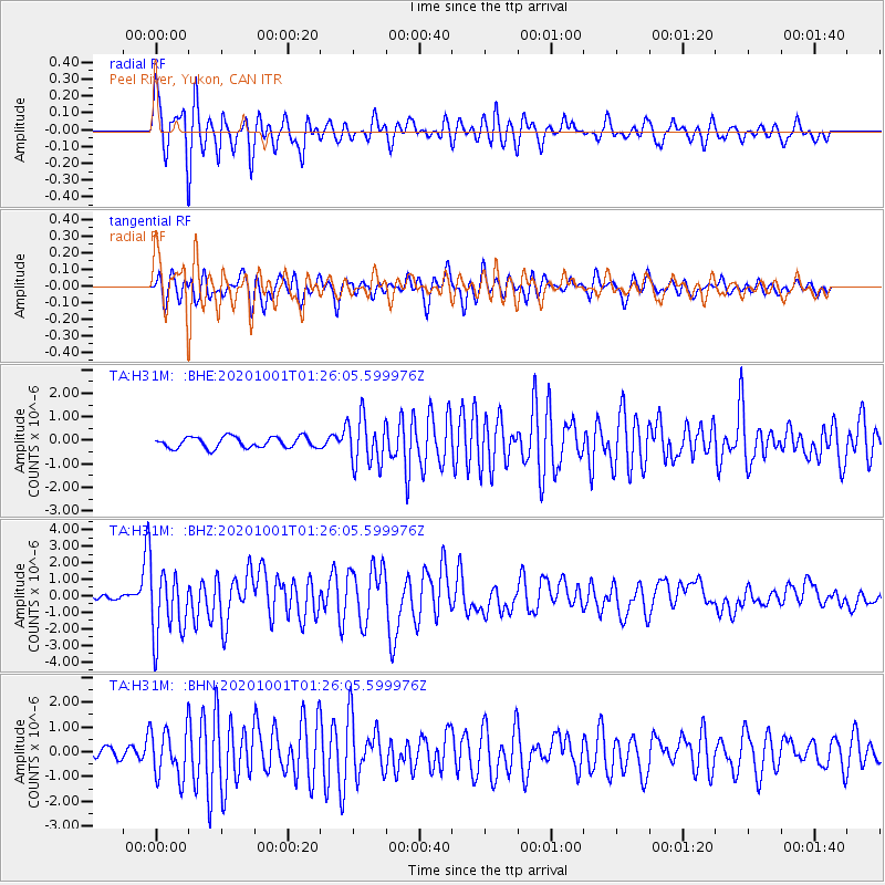
H31M Peel River, Yukon, CAN - Earthquake Result Viewer
*The percent match for this event was below the threshold and hence no stack was calculated.
| Earthquake location: |
Tonga Islands |
| Earthquake latitude/longitude: |
-19.1/-173.6 |
| Earthquake time(UTC): |
2020/10/01 (275) 01:13:39 GMT |
| Earthquake Depth: |
10 km |
| Earthquake Magnitude: |
6.7 Mi |
| Earthquake Catalog/Contributor: |
NEIC PDE/at |
|
| Network: |
TA USArray Transportable Network (new EarthScope stations) |
| Station: |
H31M Peel River, Yukon, CAN |
| Lat/Lon: |
65.81 N/134.34 W |
| Elevation: |
642 m |
|
| Distance: |
89.7 deg |
| Az: |
15.118 deg |
| Baz: |
216.756 deg |
| Ray Param: |
$rayparam |
*The percent match for this event was below the threshold and hence was not used in the summary stack. |
|
| Radial Match: |
82.92274 % |
| Radial Bump: |
400 |
| Transverse Match: |
79.64697 % |
| Transverse Bump: |
400 |
| SOD ConfigId: |
22732711 |
| Insert Time: |
2020-10-15 01:40:05.156 +0000 |
| GWidth: |
2.5 |
| Max Bumps: |
400 |
| Tol: |
0.001 |
|
Signal To Noise
| Channel | StoN | STA | LTA |
| TA:H31M: :BHZ:20201001T01:26:05.599976Z | 11.80889 | 2.0745463E-6 | 1.7567666E-7 |
| TA:H31M: :BHN:20201001T01:26:05.599976Z | 5.4350643 | 9.967735E-7 | 1.833968E-7 |
| TA:H31M: :BHE:20201001T01:26:05.599976Z | 4.367106 | 1.0167197E-6 | 2.3281316E-7 |
| Arrivals |
| Ps | |
| PpPs | |
| PsPs/PpSs | |


