You are here: Home > Network List > TA - USArray Transportable Network (new EarthScope stations) Stations List
> Station M15K Kasigluk River, AK, USA > Earthquake Result Viewer
M15K Kasigluk River, AK, USA - Earthquake Result Viewer
| Earthquake location: |
Tonga Islands |
| Earthquake latitude/longitude: |
-19.1/-173.6 |
| Earthquake time(UTC): |
2020/10/01 (275) 01:13:39 GMT |
| Earthquake Depth: |
10 km |
| Earthquake Magnitude: |
6.7 Mi |
| Earthquake Catalog/Contributor: |
NEIC PDE/at |
|
| Network: |
TA USArray Transportable Network (new EarthScope stations) |
| Station: |
M15K Kasigluk River, AK, USA |
| Lat/Lon: |
60.69 N/160.69 W |
| Elevation: |
210 m |
|
| Distance: |
80.2 deg |
| Az: |
6.405 deg |
| Baz: |
192.382 deg |
| Ray Param: |
0.048448082 |
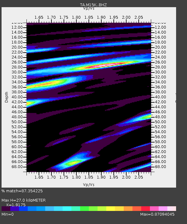
| Estimated Moho Depth: |
27.0 km |
| Estimated Crust Vp/Vs: |
1.92 |
| Assumed Crust Vp: |
6.182 km/s |
| Estimated Crust Vs: |
3.224 km/s |
| Estimated Crust Poisson's Ratio: |
0.31 |
|
| Radial Match: |
87.354225 % |
| Radial Bump: |
345 |
| Transverse Match: |
72.47083 % |
| Transverse Bump: |
400 |
| SOD ConfigId: |
22732711 |
| Insert Time: |
2020-10-15 01:40:32.618 +0000 |
| GWidth: |
2.5 |
| Max Bumps: |
400 |
| Tol: |
0.001 |
|

Signal To Noise
| Channel | StoN | STA | LTA |
| TA:M15K: :BHZ:20201001T01:25:18.075012Z | 13.340302 | 4.273717E-6 | 3.2036132E-7 |
| TA:M15K: :BHN:20201001T01:25:18.075012Z | 4.9604845 | 1.7037686E-6 | 3.4346817E-7 |
| TA:M15K: :BHE:20201001T01:25:18.075012Z | 2.1461961 | 8.758696E-7 | 4.0810326E-7 |
| Arrivals |
| Ps | 4.1 SECOND |
| PpPs | 12 SECOND |
| PsPs/PpSs | 17 SECOND |


