You are here: Home > Network List > TA - USArray Transportable Network (new EarthScope stations) Stations List
> Station M31M Drury Creek, Yukon, CA > Earthquake Result Viewer
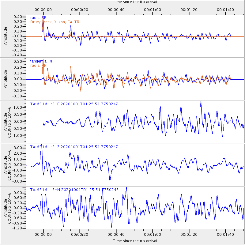
M31M Drury Creek, Yukon, CA - Earthquake Result Viewer
*The percent match for this event was below the threshold and hence no stack was calculated.
| Earthquake location: |
Tonga Islands |
| Earthquake latitude/longitude: |
-19.1/-173.6 |
| Earthquake time(UTC): |
2020/10/01 (275) 01:13:39 GMT |
| Earthquake Depth: |
10 km |
| Earthquake Magnitude: |
6.7 Mi |
| Earthquake Catalog/Contributor: |
NEIC PDE/at |
|
| Network: |
TA USArray Transportable Network (new EarthScope stations) |
| Station: |
M31M Drury Creek, Yukon, CA |
| Lat/Lon: |
62.20 N/134.39 W |
| Elevation: |
639 m |
|
| Distance: |
86.8 deg |
| Az: |
17.267 deg |
| Baz: |
216.779 deg |
| Ray Param: |
$rayparam |
*The percent match for this event was below the threshold and hence was not used in the summary stack. |
|
| Radial Match: |
78.5934 % |
| Radial Bump: |
400 |
| Transverse Match: |
69.014786 % |
| Transverse Bump: |
400 |
| SOD ConfigId: |
22732711 |
| Insert Time: |
2020-10-15 01:40:38.839 +0000 |
| GWidth: |
2.5 |
| Max Bumps: |
400 |
| Tol: |
0.001 |
|
Signal To Noise
| Channel | StoN | STA | LTA |
| TA:M31M: :BHZ:20201001T01:25:51.775024Z | 5.122019 | 1.4174998E-6 | 2.7674633E-7 |
| TA:M31M: :BHN:20201001T01:25:51.775024Z | 2.2188277 | 4.659745E-7 | 2.1000932E-7 |
| TA:M31M: :BHE:20201001T01:25:51.775024Z | 2.7253077 | 4.358689E-7 | 1.5993383E-7 |
| Arrivals |
| Ps | |
| PpPs | |
| PsPs/PpSs | |


