You are here: Home > Network List > TA - USArray Transportable Network (new EarthScope stations) Stations List
> Station P33M Teslin, Yukon, CA > Earthquake Result Viewer
P33M Teslin, Yukon, CA - Earthquake Result Viewer
| Earthquake location: |
Tonga Islands |
| Earthquake latitude/longitude: |
-19.1/-173.6 |
| Earthquake time(UTC): |
2020/10/01 (275) 01:13:39 GMT |
| Earthquake Depth: |
10 km |
| Earthquake Magnitude: |
6.7 Mi |
| Earthquake Catalog/Contributor: |
NEIC PDE/at |
|
| Network: |
TA USArray Transportable Network (new EarthScope stations) |
| Station: |
P33M Teslin, Yukon, CA |
| Lat/Lon: |
60.21 N/132.82 W |
| Elevation: |
1066 m |
|
| Distance: |
85.7 deg |
| Az: |
19.092 deg |
| Baz: |
218.276 deg |
| Ray Param: |
0.044608332 |
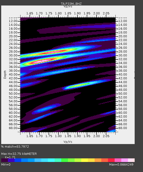
| Estimated Moho Depth: |
32.75 km |
| Estimated Crust Vp/Vs: |
1.71 |
| Assumed Crust Vp: |
6.419 km/s |
| Estimated Crust Vs: |
3.754 km/s |
| Estimated Crust Poisson's Ratio: |
0.24 |
|
| Radial Match: |
83.7972 % |
| Radial Bump: |
353 |
| Transverse Match: |
69.74738 % |
| Transverse Bump: |
400 |
| SOD ConfigId: |
22732711 |
| Insert Time: |
2020-10-15 01:41:00.765 +0000 |
| GWidth: |
2.5 |
| Max Bumps: |
400 |
| Tol: |
0.001 |
|

Signal To Noise
| Channel | StoN | STA | LTA |
| TA:P33M: :BHZ:20201001T01:25:46.275024Z | 9.734332 | 2.230911E-6 | 2.2917965E-7 |
| TA:P33M: :BHN:20201001T01:25:46.275024Z | 4.2929583 | 7.122122E-7 | 1.6590243E-7 |
| TA:P33M: :BHE:20201001T01:25:46.275024Z | 3.2904463 | 6.251129E-7 | 1.8997814E-7 |
| Arrivals |
| Ps | 3.7 SECOND |
| PpPs | 13 SECOND |
| PsPs/PpSs | 17 SECOND |


