You are here: Home > Network List > US - United States National Seismic Network Stations List
> Station MSO Missoula, Montana, USA > Earthquake Result Viewer
MSO Missoula, Montana, USA - Earthquake Result Viewer
*The percent match for this event was below the threshold and hence no stack was calculated.
| Earthquake location: |
Fiji Islands Region |
| Earthquake latitude/longitude: |
-18.0/-178.9 |
| Earthquake time(UTC): |
2017/08/19 (231) 02:00:52 GMT |
| Earthquake Depth: |
539 km |
| Earthquake Magnitude: |
6.4 Mww |
| Earthquake Catalog/Contributor: |
NEIC PDE/us |
|
| Network: |
US United States National Seismic Network |
| Station: |
MSO Missoula, Montana, USA |
| Lat/Lon: |
46.83 N/113.94 W |
| Elevation: |
1264 m |
|
| Distance: |
86.9 deg |
| Az: |
38.517 deg |
| Baz: |
239.69 deg |
| Ray Param: |
$rayparam |
*The percent match for this event was below the threshold and hence was not used in the summary stack. |
|
| Radial Match: |
49.864605 % |
| Radial Bump: |
400 |
| Transverse Match: |
74.258575 % |
| Transverse Bump: |
400 |
| SOD ConfigId: |
2140511 |
| Insert Time: |
2017-09-01 18:00:54.823 +0000 |
| GWidth: |
2.5 |
| Max Bumps: |
400 |
| Tol: |
0.001 |
|
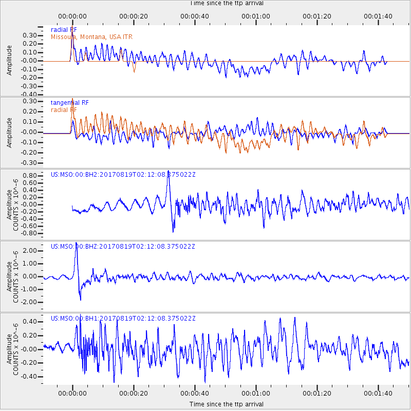
Signal To Noise
| Channel | StoN | STA | LTA |
| US:MSO:00:BHZ:20170819T02:12:08.375022Z | 11.111446 | 1.0583839E-6 | 9.5251686E-8 |
| US:MSO:00:BH1:20170819T02:12:08.375022Z | 2.0986547 | 2.0173724E-7 | 9.612694E-8 |
| US:MSO:00:BH2:20170819T02:12:08.375022Z | 3.8189006 | 4.183991E-7 | 1.095601E-7 |
| Arrivals |
| Ps | |
| PpPs | |
| PsPs/PpSs | |


