You are here: Home > Network List > TX - Texas Seismological Network Stations List
> Station FW11 UT at Arlington > Earthquake Result Viewer
FW11 UT at Arlington - Earthquake Result Viewer
| Earthquake location: |
Tonga Islands |
| Earthquake latitude/longitude: |
-19.1/-173.6 |
| Earthquake time(UTC): |
2020/10/01 (275) 01:13:39 GMT |
| Earthquake Depth: |
10 km |
| Earthquake Magnitude: |
6.7 Mi |
| Earthquake Catalog/Contributor: |
NEIC PDE/at |
|
| Network: |
TX Texas Seismological Network |
| Station: |
FW11 UT at Arlington |
| Lat/Lon: |
32.72 N/97.13 W |
| Elevation: |
198 m |
|
| Distance: |
89.3 deg |
| Az: |
55.046 deg |
| Baz: |
246.846 deg |
| Ray Param: |
0.041923724 |
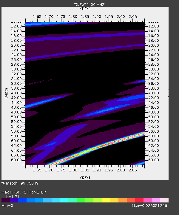
| Estimated Moho Depth: |
69.75 km |
| Estimated Crust Vp/Vs: |
1.71 |
| Assumed Crust Vp: |
6.38 km/s |
| Estimated Crust Vs: |
3.731 km/s |
| Estimated Crust Poisson's Ratio: |
0.24 |
|
| Radial Match: |
99.75049 % |
| Radial Bump: |
31 |
| Transverse Match: |
99.69876 % |
| Transverse Bump: |
29 |
| SOD ConfigId: |
22732711 |
| Insert Time: |
2020-10-15 01:42:12.617 +0000 |
| GWidth: |
2.5 |
| Max Bumps: |
400 |
| Tol: |
0.001 |
|
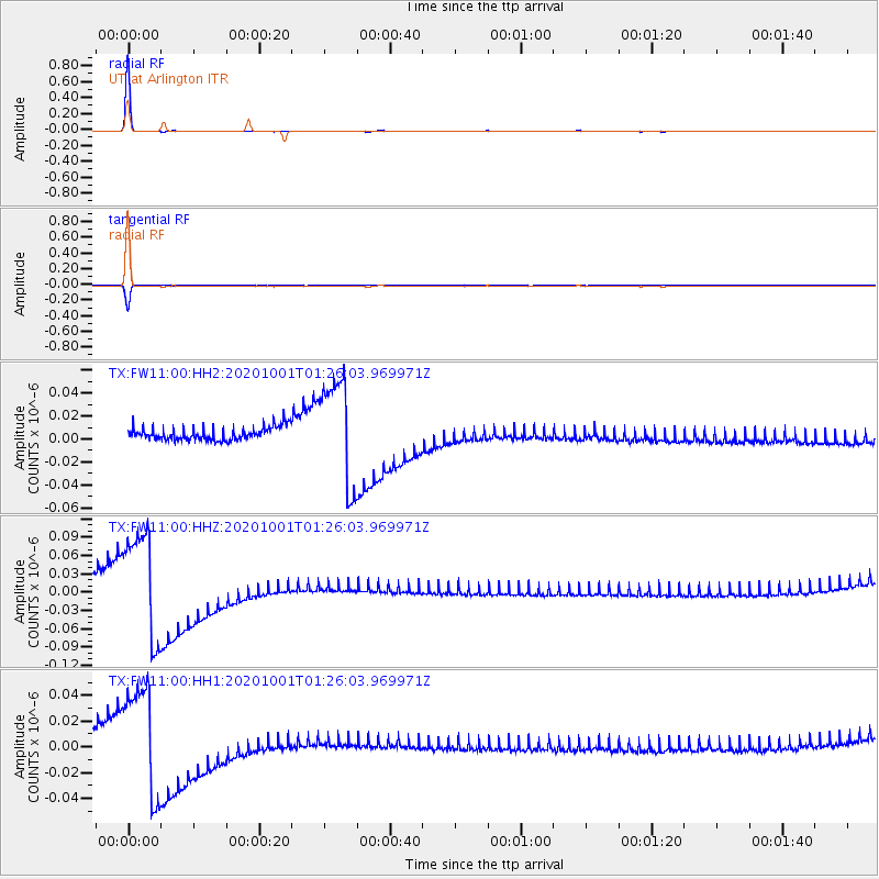
Signal To Noise
| Channel | StoN | STA | LTA |
| TX:FW11:00:HHZ:20201001T01:26:03.969971Z | 8.270659 | 8.532687E-8 | 1.0316816E-8 |
| TX:FW11:00:HH1:20201001T01:26:03.969971Z | 8.238688 | 4.103428E-8 | 4.980681E-9 |
| TX:FW11:00:HH2:20201001T01:26:03.969971Z | 8.069362 | 4.5780045E-8 | 5.6733165E-9 |
| Arrivals |
| Ps | 7.9 SECOND |
| PpPs | 29 SECOND |
| PsPs/PpSs | 37 SECOND |


