You are here: Home > Network List > TX - Texas Seismological Network Stations List
> Station FW12 Venus > Earthquake Result Viewer
FW12 Venus - Earthquake Result Viewer
| Earthquake location: |
Tonga Islands |
| Earthquake latitude/longitude: |
-19.1/-173.6 |
| Earthquake time(UTC): |
2020/10/01 (275) 01:13:39 GMT |
| Earthquake Depth: |
10 km |
| Earthquake Magnitude: |
6.7 Mi |
| Earthquake Catalog/Contributor: |
NEIC PDE/at |
|
| Network: |
TX Texas Seismological Network |
| Station: |
FW12 Venus |
| Lat/Lon: |
32.50 N/97.15 W |
| Elevation: |
204 m |
|
| Distance: |
89.2 deg |
| Az: |
55.244 deg |
| Baz: |
246.837 deg |
| Ray Param: |
0.042000566 |
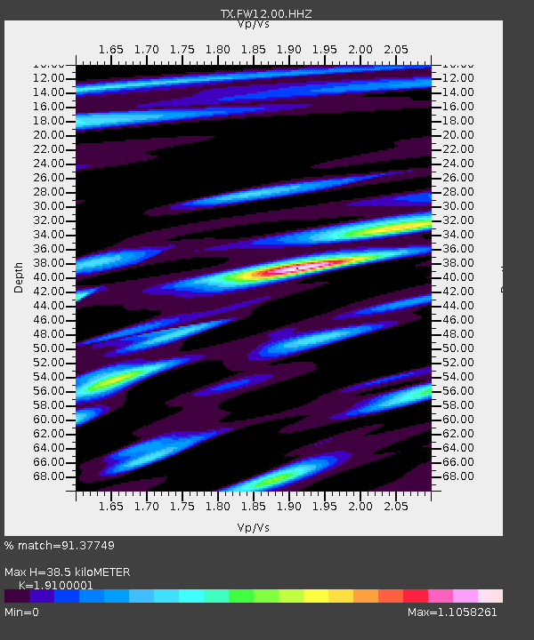
| Estimated Moho Depth: |
38.5 km |
| Estimated Crust Vp/Vs: |
1.91 |
| Assumed Crust Vp: |
6.38 km/s |
| Estimated Crust Vs: |
3.341 km/s |
| Estimated Crust Poisson's Ratio: |
0.31 |
|
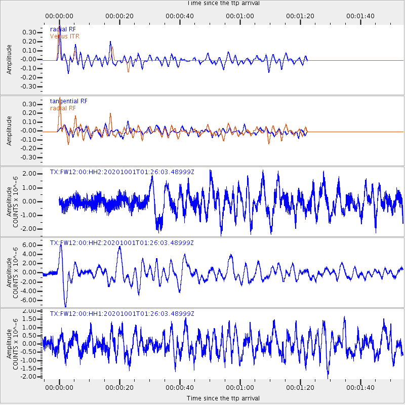
| Radial Match: |
91.37749 % |
| Radial Bump: |
400 |
| Transverse Match: |
78.99574 % |
| Transverse Bump: |
400 |
| SOD ConfigId: |
22732711 |
| Insert Time: |
2020-10-15 01:42:15.708 +0000 |
| GWidth: |
2.5 |
| Max Bumps: |
400 |
| Tol: |
0.001 |
|
Signal To Noise
| Channel | StoN | STA | LTA |
| TX:FW12:00:HHZ:20201001T01:26:03.48999Z | 15.929204 | 3.6937317E-6 | 2.3188427E-7 |
| TX:FW12:00:HH1:20201001T01:26:03.48999Z | 1.5741265 | 4.856845E-7 | 3.085422E-7 |
| TX:FW12:00:HH2:20201001T01:26:03.48999Z | 3.3049781 | 1.2154558E-6 | 3.6776513E-7 |
| Arrivals |
| Ps | 5.6 SECOND |
| PpPs | 17 SECOND |
| PsPs/PpSs | 23 SECOND |


