You are here: Home > Network List > TX - Texas Seismological Network Stations List
> Station PB03 Z > Earthquake Result Viewer
PB03 Z - Earthquake Result Viewer
| Earthquake location: |
Tonga Islands |
| Earthquake latitude/longitude: |
-19.1/-173.6 |
| Earthquake time(UTC): |
2020/10/01 (275) 01:13:39 GMT |
| Earthquake Depth: |
10 km |
| Earthquake Magnitude: |
6.7 Mi |
| Earthquake Catalog/Contributor: |
NEIC PDE/at |
|
| Network: |
TX Texas Seismological Network |
| Station: |
PB03 Z |
| Lat/Lon: |
31.08 N/103.51 W |
| Elevation: |
817 m |
|
| Distance: |
83.7 deg |
| Az: |
54.242 deg |
| Baz: |
243.436 deg |
| Ray Param: |
0.04598391 |
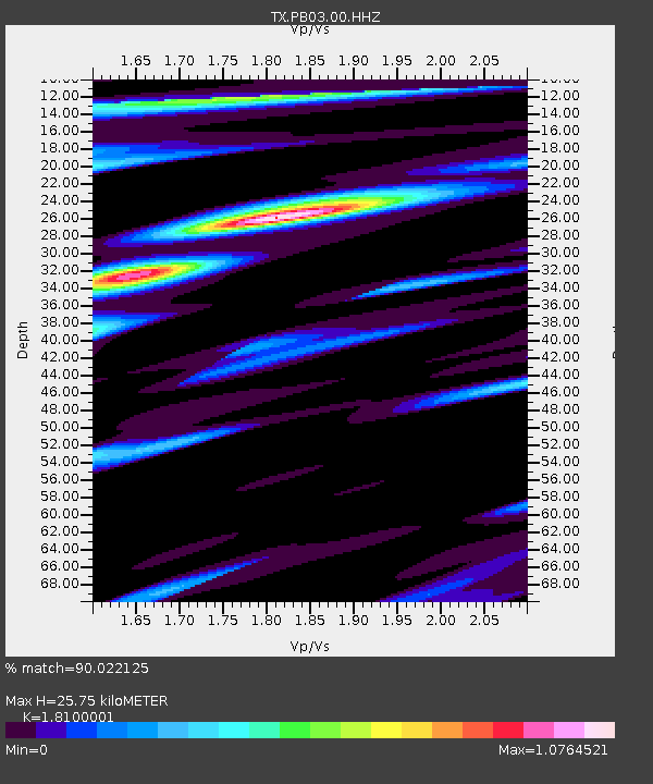
| Estimated Moho Depth: |
25.75 km |
| Estimated Crust Vp/Vs: |
1.81 |
| Assumed Crust Vp: |
6.121 km/s |
| Estimated Crust Vs: |
3.381 km/s |
| Estimated Crust Poisson's Ratio: |
0.28 |
|
| Radial Match: |
90.022125 % |
| Radial Bump: |
400 |
| Transverse Match: |
82.64582 % |
| Transverse Bump: |
400 |
| SOD ConfigId: |
22732711 |
| Insert Time: |
2020-10-15 01:42:41.472 +0000 |
| GWidth: |
2.5 |
| Max Bumps: |
400 |
| Tol: |
0.001 |
|

Signal To Noise
| Channel | StoN | STA | LTA |
| TX:PB03:00:HHZ:20201001T01:25:36.570007Z | 29.660233 | 6.335567E-6 | 2.1360475E-7 |
| TX:PB03:00:HH1:20201001T01:25:36.570007Z | 5.8189154 | 6.574518E-7 | 1.12985276E-7 |
| TX:PB03:00:HH2:20201001T01:25:36.570007Z | 13.779531 | 1.6167896E-6 | 1.1733271E-7 |
| Arrivals |
| Ps | 3.5 SECOND |
| PpPs | 12 SECOND |
| PsPs/PpSs | 15 SECOND |


