You are here: Home > Network List > TX - Texas Seismological Network Stations List
> Station PLPT Palo Pinto > Earthquake Result Viewer
PLPT Palo Pinto - Earthquake Result Viewer
| Earthquake location: |
Tonga Islands |
| Earthquake latitude/longitude: |
-19.1/-173.6 |
| Earthquake time(UTC): |
2020/10/01 (275) 01:13:39 GMT |
| Earthquake Depth: |
10 km |
| Earthquake Magnitude: |
6.7 Mi |
| Earthquake Catalog/Contributor: |
NEIC PDE/at |
|
| Network: |
TX Texas Seismological Network |
| Station: |
PLPT Palo Pinto |
| Lat/Lon: |
32.81 N/98.32 W |
| Elevation: |
336 m |
|
| Distance: |
88.5 deg |
| Az: |
54.565 deg |
| Baz: |
246.197 deg |
| Ray Param: |
0.042570647 |
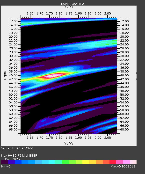
| Estimated Moho Depth: |
39.75 km |
| Estimated Crust Vp/Vs: |
1.76 |
| Assumed Crust Vp: |
6.426 km/s |
| Estimated Crust Vs: |
3.646 km/s |
| Estimated Crust Poisson's Ratio: |
0.26 |
|
| Radial Match: |
94.964966 % |
| Radial Bump: |
358 |
| Transverse Match: |
82.070915 % |
| Transverse Bump: |
323 |
| SOD ConfigId: |
22732711 |
| Insert Time: |
2020-10-15 01:43:08.778 +0000 |
| GWidth: |
2.5 |
| Max Bumps: |
400 |
| Tol: |
0.001 |
|

Signal To Noise
| Channel | StoN | STA | LTA |
| TX:PLPT:00:HHZ:20201001T01:25:59.830017Z | 56.15712 | 6.0393118E-6 | 1.0754312E-7 |
| TX:PLPT:00:HH1:20201001T01:25:59.830017Z | 20.873743 | 2.1473456E-6 | 1.0287305E-7 |
| TX:PLPT:00:HH2:20201001T01:25:59.830017Z | 3.6769176 | 4.8646984E-7 | 1.3230371E-7 |
| Arrivals |
| Ps | 4.8 SECOND |
| PpPs | 17 SECOND |
| PsPs/PpSs | 22 SECOND |


