You are here: Home > Network List > TX - Texas Seismological Network Stations List
> Station SMWD Samnorwood > Earthquake Result Viewer
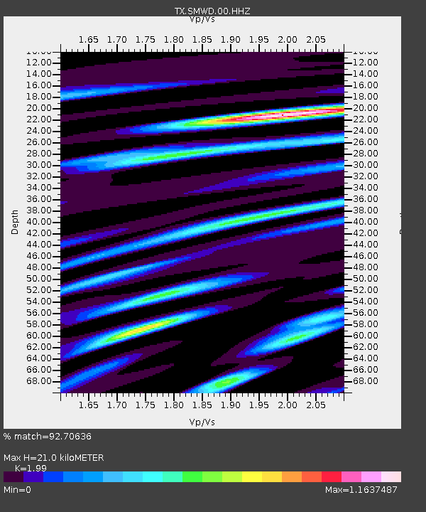
SMWD Samnorwood - Earthquake Result Viewer
| Earthquake location: |
Tonga Islands |
| Earthquake latitude/longitude: |
-19.1/-173.6 |
| Earthquake time(UTC): |
2020/10/01 (275) 01:13:39 GMT |
| Earthquake Depth: |
10 km |
| Earthquake Magnitude: |
6.7 Mi |
| Earthquake Catalog/Contributor: |
NEIC PDE/at |
|
| Network: |
TX Texas Seismological Network |
| Station: |
SMWD Samnorwood |
| Lat/Lon: |
35.10 N/100.24 W |
| Elevation: |
704 m |
|
| Distance: |
87.9 deg |
| Az: |
51.82 deg |
| Baz: |
245.039 deg |
| Ray Param: |
0.04295532 |
| Estimated Moho Depth: |
21.0 km |
| Estimated Crust Vp/Vs: |
1.99 |
| Assumed Crust Vp: |
6.426 km/s |
| Estimated Crust Vs: |
3.229 km/s |
| Estimated Crust Poisson's Ratio: |
0.33 |
|
| Radial Match: |
92.70636 % |
| Radial Bump: |
400 |
| Transverse Match: |
77.14204 % |
| Transverse Bump: |
400 |
| SOD ConfigId: |
22732711 |
| Insert Time: |
2020-10-15 01:43:16.227 +0000 |
| GWidth: |
2.5 |
| Max Bumps: |
400 |
| Tol: |
0.001 |
|

Signal To Noise
| Channel | StoN | STA | LTA |
| TX:SMWD:00:HHZ:20201001T01:25:57.38501Z | 19.635654 | 3.626461E-6 | 1.8468755E-7 |
| TX:SMWD:00:HH1:20201001T01:25:57.38501Z | 2.1942515 | 2.6795692E-7 | 1.2211768E-7 |
| TX:SMWD:00:HH2:20201001T01:25:57.38501Z | 10.060708 | 1.2097314E-6 | 1.2024316E-7 |
| Arrivals |
| Ps | 3.3 SECOND |
| PpPs | 9.6 SECOND |
| PsPs/PpSs | 13 SECOND |


