You are here: Home > Network List > TX - Texas Seismological Network Stations List
> Station WTFS Witchita Falls > Earthquake Result Viewer
WTFS Witchita Falls - Earthquake Result Viewer
| Earthquake location: |
Tonga Islands |
| Earthquake latitude/longitude: |
-19.1/-173.6 |
| Earthquake time(UTC): |
2020/10/01 (275) 01:13:39 GMT |
| Earthquake Depth: |
10 km |
| Earthquake Magnitude: |
6.7 Mi |
| Earthquake Catalog/Contributor: |
NEIC PDE/at |
|
| Network: |
TX Texas Seismological Network |
| Station: |
WTFS Witchita Falls |
| Lat/Lon: |
33.77 N/98.46 W |
| Elevation: |
277 m |
|
| Distance: |
88.7 deg |
| Az: |
53.644 deg |
| Baz: |
246.093 deg |
| Ray Param: |
0.042368434 |
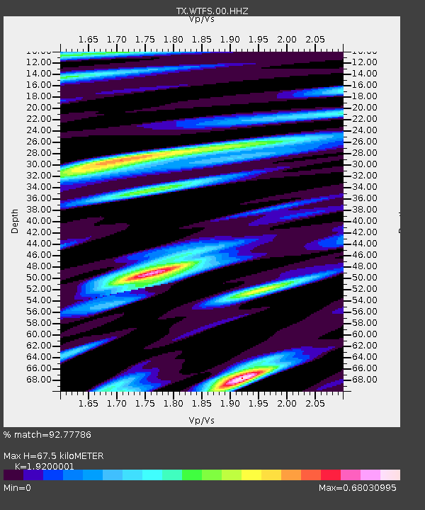
| Estimated Moho Depth: |
67.5 km |
| Estimated Crust Vp/Vs: |
1.92 |
| Assumed Crust Vp: |
6.426 km/s |
| Estimated Crust Vs: |
3.347 km/s |
| Estimated Crust Poisson's Ratio: |
0.31 |
|
| Radial Match: |
92.77786 % |
| Radial Bump: |
382 |
| Transverse Match: |
87.45391 % |
| Transverse Bump: |
351 |
| SOD ConfigId: |
22732711 |
| Insert Time: |
2020-10-15 01:43:28.528 +0000 |
| GWidth: |
2.5 |
| Max Bumps: |
400 |
| Tol: |
0.001 |
|
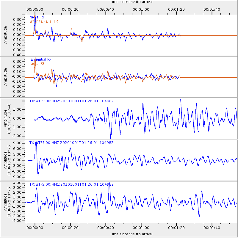
Signal To Noise
| Channel | StoN | STA | LTA |
| TX:WTFS:00:HHZ:20201001T01:26:01.10498Z | 48.333668 | 4.8838397E-6 | 1.0104426E-7 |
| TX:WTFS:00:HH1:20201001T01:26:01.10498Z | 10.377778 | 1.4267556E-6 | 1.374818E-7 |
| TX:WTFS:00:HH2:20201001T01:26:01.10498Z | 2.553603 | 4.1399363E-7 | 1.6212138E-7 |
| Arrivals |
| Ps | 9.9 SECOND |
| PpPs | 30 SECOND |
| PsPs/PpSs | 40 SECOND |


