You are here: Home > Network List > TX - Texas Seismological Network Stations List
> Station PB17 Fort Stockton > Earthquake Result Viewer
PB17 Fort Stockton - Earthquake Result Viewer
| Earthquake location: |
Tonga Islands |
| Earthquake latitude/longitude: |
-19.1/-173.6 |
| Earthquake time(UTC): |
2020/10/01 (275) 01:13:39 GMT |
| Earthquake Depth: |
10 km |
| Earthquake Magnitude: |
6.7 Mi |
| Earthquake Catalog/Contributor: |
NEIC PDE/at |
|
| Network: |
TX Texas Seismological Network |
| Station: |
PB17 Fort Stockton |
| Lat/Lon: |
31.00 N/103.15 W |
| Elevation: |
734 m |
|
| Distance: |
84.0 deg |
| Az: |
54.46 deg |
| Baz: |
243.645 deg |
| Ray Param: |
0.04581055 |
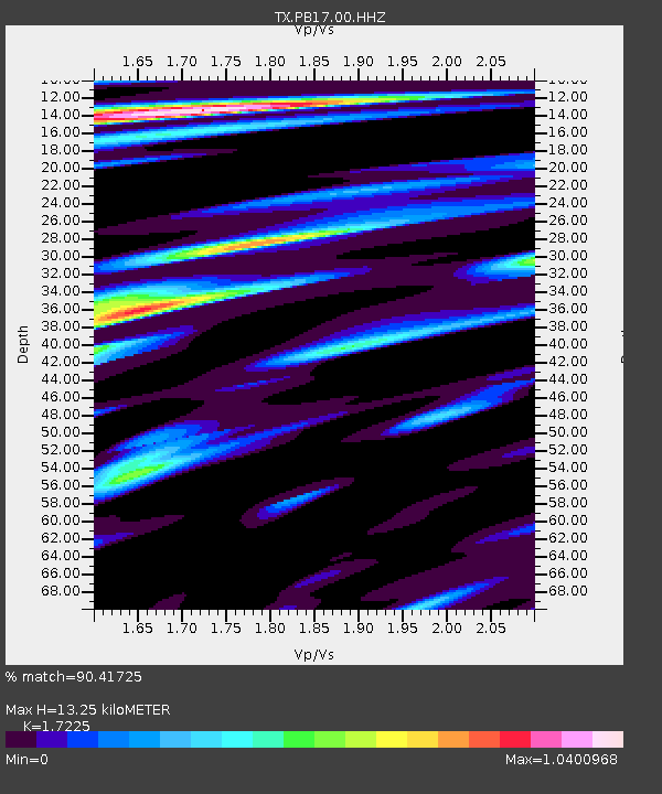
| Estimated Moho Depth: |
13.25 km |
| Estimated Crust Vp/Vs: |
1.72 |
| Assumed Crust Vp: |
6.121 km/s |
| Estimated Crust Vs: |
3.553 km/s |
| Estimated Crust Poisson's Ratio: |
0.25 |
|
| Radial Match: |
90.41725 % |
| Radial Bump: |
400 |
| Transverse Match: |
86.34417 % |
| Transverse Bump: |
400 |
| SOD ConfigId: |
22732711 |
| Insert Time: |
2020-10-15 01:43:30.815 +0000 |
| GWidth: |
2.5 |
| Max Bumps: |
400 |
| Tol: |
0.001 |
|

Signal To Noise
| Channel | StoN | STA | LTA |
| TX:PB17:00:HHZ:20201001T01:25:37.789978Z | 31.271856 | 7.3123974E-6 | 2.3383318E-7 |
| TX:PB17:00:HH1:20201001T01:25:37.789978Z | 4.520973 | 7.4324277E-7 | 1.6439884E-7 |
| TX:PB17:00:HH2:20201001T01:25:37.789978Z | 7.9842834 | 1.8909183E-6 | 2.3683006E-7 |
| Arrivals |
| Ps | 1.6 SECOND |
| PpPs | 5.8 SECOND |
| PsPs/PpSs | 7.4 SECOND |


