You are here: Home > Network List > UU - University of Utah Regional Network Stations List
> Station CVRU Castle Valley Ranch, Emery, UT, USA old TA-Q16A > Earthquake Result Viewer
CVRU Castle Valley Ranch, Emery, UT, USA old TA-Q16A - Earthquake Result Viewer
| Earthquake location: |
Fiji Islands Region |
| Earthquake latitude/longitude: |
-18.0/-178.9 |
| Earthquake time(UTC): |
2017/08/19 (231) 02:00:52 GMT |
| Earthquake Depth: |
539 km |
| Earthquake Magnitude: |
6.4 Mww |
| Earthquake Catalog/Contributor: |
NEIC PDE/us |
|
| Network: |
UU University of Utah Regional Network |
| Station: |
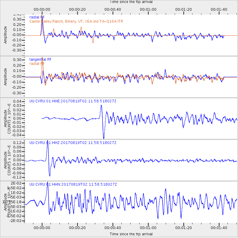
CVRU Castle Valley Ranch, Emery, UT, USA old TA-Q16A |
| Lat/Lon: |
38.92 N/111.17 W |
| Elevation: |
1912 m |
|
| Distance: |
84.8 deg |
| Az: |
46.436 deg |
| Baz: |
242.145 deg |
| Ray Param: |
0.04366779 |
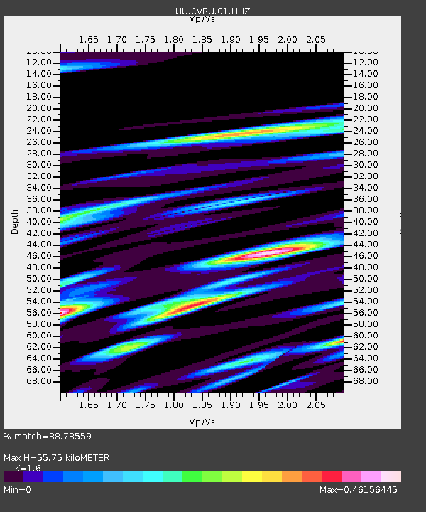
| Estimated Moho Depth: |
55.75 km |
| Estimated Crust Vp/Vs: |
1.60 |
| Assumed Crust Vp: |
6.207 km/s |
| Estimated Crust Vs: |
3.879 km/s |
| Estimated Crust Poisson's Ratio: |
0.18 |
|
| Radial Match: |
88.78559 % |
| Radial Bump: |
400 |
| Transverse Match: |
84.944824 % |
| Transverse Bump: |
400 |
| SOD ConfigId: |
2140511 |
| Insert Time: |
2017-09-01 18:01:23.287 +0000 |
| GWidth: |
2.5 |
| Max Bumps: |
400 |
| Tol: |
0.001 |
|
Signal To Noise
| Channel | StoN | STA | LTA |
| UU:CVRU:01:HHZ:20170819T02:11:58.518027Z | 26.165243 | 5.9229926E-8 | 2.2636872E-9 |
| UU:CVRU:01:HHN:20170819T02:11:58.518027Z | 3.5807972 | 9.066808E-9 | 2.5320641E-9 |
| UU:CVRU:01:HHE:20170819T02:11:58.518027Z | 10.27103 | 1.5758008E-8 | 1.5342188E-9 |
| Arrivals |
| Ps | 5.5 SECOND |
| PpPs | 23 SECOND |
| PsPs/PpSs | 28 SECOND |


