You are here: Home > Network List > UU - University of Utah Regional Network Stations List
> Station BGU Big Grassy Mountain, UT, USA > Earthquake Result Viewer
BGU Big Grassy Mountain, UT, USA - Earthquake Result Viewer
| Earthquake location: |
Tonga Islands |
| Earthquake latitude/longitude: |
-19.1/-173.6 |
| Earthquake time(UTC): |
2020/10/01 (275) 01:13:39 GMT |
| Earthquake Depth: |
10 km |
| Earthquake Magnitude: |
6.7 Mi |
| Earthquake Catalog/Contributor: |
NEIC PDE/at |
|
| Network: |
UU University of Utah Regional Network |
| Station: |
BGU Big Grassy Mountain, UT, USA |
| Lat/Lon: |
40.92 N/113.03 W |
| Elevation: |
1640 m |
|
| Distance: |
82.0 deg |
| Az: |
41.802 deg |
| Baz: |
236.282 deg |
| Ray Param: |
0.047222003 |
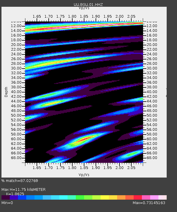
| Estimated Moho Depth: |
11.75 km |
| Estimated Crust Vp/Vs: |
1.86 |
| Assumed Crust Vp: |
6.276 km/s |
| Estimated Crust Vs: |
3.37 km/s |
| Estimated Crust Poisson's Ratio: |
0.30 |
|
| Radial Match: |
87.02769 % |
| Radial Bump: |
400 |
| Transverse Match: |
72.879814 % |
| Transverse Bump: |
400 |
| SOD ConfigId: |
22732711 |
| Insert Time: |
2020-10-15 01:45:30.197 +0000 |
| GWidth: |
2.5 |
| Max Bumps: |
400 |
| Tol: |
0.001 |
|

Signal To Noise
| Channel | StoN | STA | LTA |
| UU:BGU:01:HHZ:20201001T01:25:27.427979Z | 24.603695 | 8.4789676E-8 | 3.4462173E-9 |
| UU:BGU:01:HHN:20201001T01:25:27.427979Z | 6.071115 | 1.6533871E-8 | 2.7233664E-9 |
| UU:BGU:01:HHE:20201001T01:25:27.427979Z | 6.884261 | 2.434634E-8 | 3.5365217E-9 |
| Arrivals |
| Ps | 1.7 SECOND |
| PpPs | 5.2 SECOND |
| PsPs/PpSs | 6.9 SECOND |


