You are here: Home > Network List > UU - University of Utah Regional Network Stations List
> Station HVU Hansel Valley, UT, USA > Earthquake Result Viewer
HVU Hansel Valley, UT, USA - Earthquake Result Viewer

| Earthquake location: |
Tonga Islands |
| Earthquake latitude/longitude: |
-19.1/-173.6 |
| Earthquake time(UTC): |
2020/10/01 (275) 01:13:39 GMT |
| Earthquake Depth: |
10 km |
| Earthquake Magnitude: |
6.7 Mi |
| Earthquake Catalog/Contributor: |
NEIC PDE/at |
|
| Network: |
UU University of Utah Regional Network |
| Station: |
HVU Hansel Valley, UT, USA |
| Lat/Lon: |
41.78 N/112.78 W |
| Elevation: |
1609 m |
|
| Distance: |
82.6 deg |
| Az: |
41.188 deg |
| Baz: |
236.367 deg |
| Ray Param: |
0.046782114 |
| Estimated Moho Depth: |
44.75 km |
| Estimated Crust Vp/Vs: |
1.94 |
| Assumed Crust Vp: |
6.276 km/s |
| Estimated Crust Vs: |
3.239 km/s |
| Estimated Crust Poisson's Ratio: |
0.32 |
|
| Radial Match: |
93.80517 % |
| Radial Bump: |
312 |
| Transverse Match: |
84.496796 % |
| Transverse Bump: |
372 |
| SOD ConfigId: |
22732711 |
| Insert Time: |
2020-10-15 01:45:50.654 +0000 |
| GWidth: |
2.5 |
| Max Bumps: |
400 |
| Tol: |
0.001 |
|
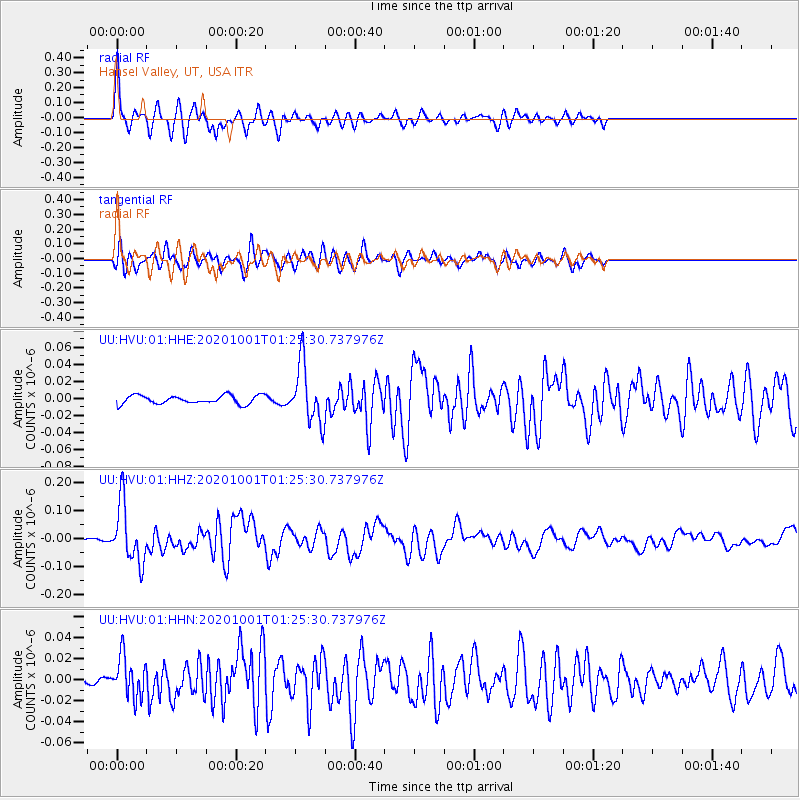
Signal To Noise
| Channel | StoN | STA | LTA |
| UU:HVU:01:HHZ:20201001T01:25:30.737976Z | 23.918201 | 1.0456328E-7 | 4.371703E-9 |
| UU:HVU:01:HHN:20201001T01:25:30.737976Z | 4.2514396 | 1.904079E-8 | 4.478669E-9 |
| UU:HVU:01:HHE:20201001T01:25:30.737976Z | 6.9356112 | 3.4450704E-8 | 4.9672195E-9 |
| Arrivals |
| Ps | 6.8 SECOND |
| PpPs | 20 SECOND |
| PsPs/PpSs | 27 SECOND |


