You are here: Home > Network List > UU - University of Utah Regional Network Stations List
> Station KNB Kanab, UT, USA > Earthquake Result Viewer
KNB Kanab, UT, USA - Earthquake Result Viewer
| Earthquake location: |
Tonga Islands |
| Earthquake latitude/longitude: |
-19.1/-173.6 |
| Earthquake time(UTC): |
2020/10/01 (275) 01:13:39 GMT |
| Earthquake Depth: |
10 km |
| Earthquake Magnitude: |
6.7 Mi |
| Earthquake Catalog/Contributor: |
NEIC PDE/at |
|
| Network: |
UU University of Utah Regional Network |
| Station: |
KNB Kanab, UT, USA |
| Lat/Lon: |
37.02 N/112.82 W |
| Elevation: |
1715 m |
|
| Distance: |
79.9 deg |
| Az: |
45.188 deg |
| Baz: |
236.944 deg |
| Ray Param: |
0.04861755 |
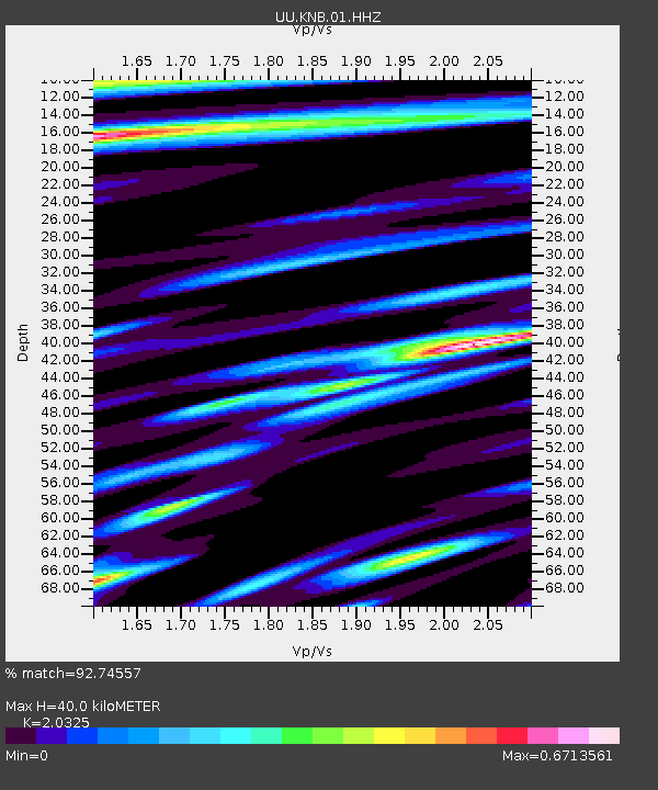
| Estimated Moho Depth: |
40.0 km |
| Estimated Crust Vp/Vs: |
2.03 |
| Assumed Crust Vp: |
6.194 km/s |
| Estimated Crust Vs: |
3.048 km/s |
| Estimated Crust Poisson's Ratio: |
0.34 |
|
| Radial Match: |
92.74557 % |
| Radial Bump: |
400 |
| Transverse Match: |
79.40665 % |
| Transverse Bump: |
400 |
| SOD ConfigId: |
22732711 |
| Insert Time: |
2020-10-15 01:45:52.013 +0000 |
| GWidth: |
2.5 |
| Max Bumps: |
400 |
| Tol: |
0.001 |
|
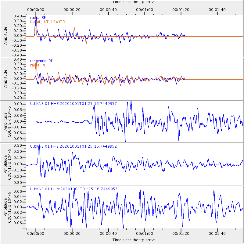
Signal To Noise
| Channel | StoN | STA | LTA |
| UU:KNB:01:HHZ:20201001T01:25:16.744995Z | 29.107286 | 1.3611835E-7 | 4.6764352E-9 |
| UU:KNB:01:HHN:20201001T01:25:16.744995Z | 3.3874223 | 2.4851877E-8 | 7.336516E-9 |
| UU:KNB:01:HHE:20201001T01:25:16.744995Z | 15.135455 | 3.8650025E-8 | 2.5536084E-9 |
| Arrivals |
| Ps | 6.8 SECOND |
| PpPs | 19 SECOND |
| PsPs/PpSs | 26 SECOND |


