You are here: Home > Network List > UU - University of Utah Regional Network Stations List
> Station SPU South Promontory Point, UT, USA > Earthquake Result Viewer
SPU South Promontory Point, UT, USA - Earthquake Result Viewer
| Earthquake location: |
Tonga Islands |
| Earthquake latitude/longitude: |
-19.1/-173.6 |
| Earthquake time(UTC): |
2020/10/01 (275) 01:13:39 GMT |
| Earthquake Depth: |
10 km |
| Earthquake Magnitude: |
6.7 Mi |
| Earthquake Catalog/Contributor: |
NEIC PDE/at |
|
| Network: |
UU University of Utah Regional Network |
| Station: |
SPU South Promontory Point, UT, USA |
| Lat/Lon: |
41.31 N/112.45 W |
| Elevation: |
2086 m |
|
| Distance: |
82.5 deg |
| Az: |
41.72 deg |
| Baz: |
236.651 deg |
| Ray Param: |
0.046817552 |
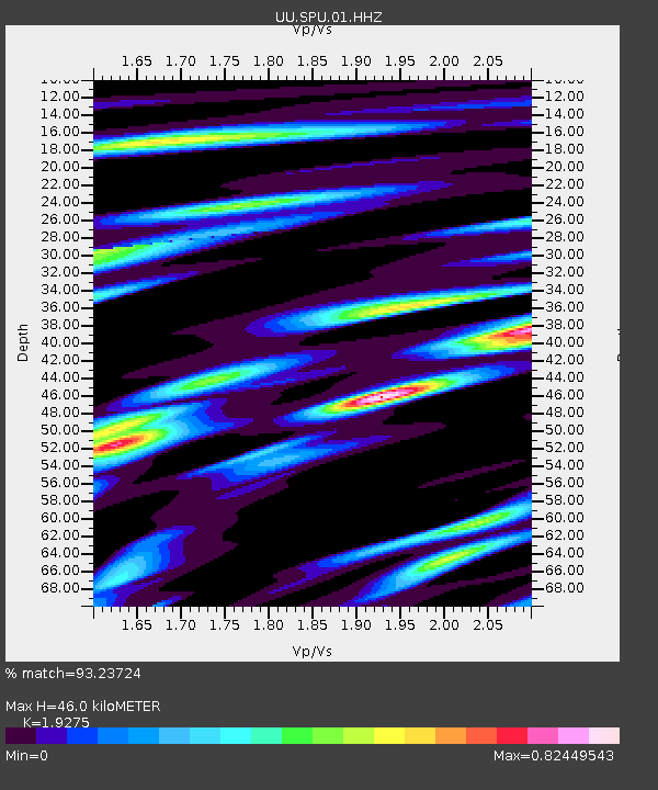
| Estimated Moho Depth: |
46.0 km |
| Estimated Crust Vp/Vs: |
1.93 |
| Assumed Crust Vp: |
6.276 km/s |
| Estimated Crust Vs: |
3.256 km/s |
| Estimated Crust Poisson's Ratio: |
0.32 |
|
| Radial Match: |
93.23724 % |
| Radial Bump: |
342 |
| Transverse Match: |
89.53879 % |
| Transverse Bump: |
400 |
| SOD ConfigId: |
22732711 |
| Insert Time: |
2020-10-15 01:46:06.738 +0000 |
| GWidth: |
2.5 |
| Max Bumps: |
400 |
| Tol: |
0.001 |
|

Signal To Noise
| Channel | StoN | STA | LTA |
| UU:SPU:01:HHZ:20201001T01:25:30.455017Z | 37.693634 | 1.18725644E-7 | 3.1497533E-9 |
| UU:SPU:01:HHN:20201001T01:25:30.455017Z | 7.7098413 | 2.8939885E-8 | 3.7536294E-9 |
| UU:SPU:01:HHE:20201001T01:25:30.455017Z | 9.059801 | 4.3573344E-8 | 4.8095252E-9 |
| Arrivals |
| Ps | 7.0 SECOND |
| PpPs | 21 SECOND |
| PsPs/PpSs | 28 SECOND |


