You are here: Home > Network List > UU - University of Utah Regional Network Stations List
> Station TCU Toone Canyon, UT, USA > Earthquake Result Viewer
TCU Toone Canyon, UT, USA - Earthquake Result Viewer
| Earthquake location: |
Tonga Islands |
| Earthquake latitude/longitude: |
-19.1/-173.6 |
| Earthquake time(UTC): |
2020/10/01 (275) 01:13:39 GMT |
| Earthquake Depth: |
10 km |
| Earthquake Magnitude: |
6.7 Mi |
| Earthquake Catalog/Contributor: |
NEIC PDE/at |
|
| Network: |
UU University of Utah Regional Network |
| Station: |
TCU Toone Canyon, UT, USA |
| Lat/Lon: |
41.12 N/111.41 W |
| Elevation: |
2269 m |
|
| Distance: |
83.1 deg |
| Az: |
42.313 deg |
| Baz: |
237.409 deg |
| Ray Param: |
0.046433188 |
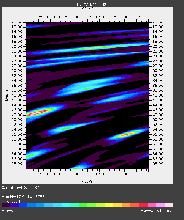
| Estimated Moho Depth: |
47.0 km |
| Estimated Crust Vp/Vs: |
1.64 |
| Assumed Crust Vp: |
6.155 km/s |
| Estimated Crust Vs: |
3.753 km/s |
| Estimated Crust Poisson's Ratio: |
0.20 |
|
| Radial Match: |
90.47584 % |
| Radial Bump: |
400 |
| Transverse Match: |
92.476974 % |
| Transverse Bump: |
400 |
| SOD ConfigId: |
22732711 |
| Insert Time: |
2020-10-15 01:46:14.686 +0000 |
| GWidth: |
2.5 |
| Max Bumps: |
400 |
| Tol: |
0.001 |
|

Signal To Noise
| Channel | StoN | STA | LTA |
| UU:TCU:01:HHZ:20201001T01:25:33.325012Z | 22.914787 | 1.6892065E-7 | 7.3716873E-9 |
| UU:TCU:01:HHN:20201001T01:25:33.325012Z | 9.154274 | 3.499244E-8 | 3.8225245E-9 |
| UU:TCU:01:HHE:20201001T01:25:33.325012Z | 6.9558415 | 6.7740935E-8 | 9.738712E-9 |
| Arrivals |
| Ps | 5.0 SECOND |
| PpPs | 20 SECOND |
| PsPs/PpSs | 25 SECOND |


